| Date: | 1920 |
|---|---|
| Description: | View along top of cliff toward cottages along a rocky coast. A large building is in the distance on the right. |

| Date: | |
|---|---|
| Description: | View of men surf fishing along a rocky shoreline at Point State Park. |

| Date: | |
|---|---|
| Description: | Homes stand along the coast near cliffs on Block Island. |

| Date: | |
|---|---|
| Description: | Elevated view of Bermuda shoreline. Several dwellings stand on top of the island and people swim in the ocean on the beaches below. |

| Date: | 1902 |
|---|---|
| Description: | Map of Southern Norway with text in Norwegian. The scale of the map is 1:500000. |

| Date: | 1902 |
|---|---|
| Description: | Map of Southern Norway with text in Norwegian. Scale of map 1:500000. |

| Date: | |
|---|---|
| Description: | View looking down dune towards a man wearing a helmet driving a Scout. Trees and plants are on top of the dunes. The Scout has a windshield and roll bars i... |

| Date: | 1755 |
|---|---|
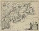
| Description: | Map of the northeastern portion of America and Canada, east of the Hudson River and south from Labrador. It names regions, colonies, cities, numerous forts... |

| Date: | 1795 |
|---|---|
| Description: | Map of Maine, showing a few cities, harbors, hills, mountains, lakes, and rivers. A road runs from Pownalboro south to Portsmouth harbor, and the boundary ... |

| Date: | 1795 |
|---|---|
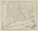
| Description: | Map of Connecticut showing counties, townships, cities, roads, islands, swamps, hills, mountains, lakes, rivers, reefs, and numerous other geographical and... |

| Date: | 10 1776 |
|---|---|
| Description: | Broadside map showing the British invasion of New York city in August and September of 1776. The map shows important cities, forts, roads, hills, mountains... |

| Date: | 02 1777 |
|---|---|
| Description: | Map depicting the campaigns of October and November 1776, in Manhattan, Westchester, and part of New Jersey, published only a few months after the conclusi... |

| Date: | 11 1781 |
|---|---|
| Description: | Map of New York, Staten Island, and Long Island, showing the placements of forts, and the movement of troops in 1776. The map also includes towns, cities, ... |

| Date: | 1779 |
|---|---|
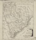
| Description: | Map of South Carolina showing boundary lines, Native American land, precincts, townships, cities, towns, forts, roads, mountains, hills, swamps, islands, a... |

| Date: | 1779 |
|---|---|
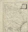
| Description: | Map of colonial Georgia showing cities, towns, Native American land and towns, forts, roads, trading paths, islands, mountains, swamps, and rivers. Annotat... |
If you didn't find the material you searched for, our Library Reference Staff can help.
Call our reference desk at 608-264-6535 or email us at: