 Filter: Categories of Wisconsin Historical Images
Filter: Subject of Hats
Filter: Subject of intellectual life
Filter: Subject of international relations
Filter: Categories of Wisconsin Historical Images
Filter: Subject of Hats
Filter: Subject of intellectual life
Filter: Subject of international relations

| Date: | 12 01 1944 |
|---|---|
| Description: | Ambassador Lord (Edward Frederick Lindley Wood) and Lady Halifax, British ambassador to the United States, at the train station. Left to right: Lady Halifa... |
| Date: | 12 29 1970 |
|---|---|
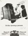
| Description: | Poster advocating the boycott of Polaroid cameras due to the company's supposed involvement in South Africa's apartheid regime. A list of grievances and de... |

| Date: | 11 04 1949 |
|---|---|
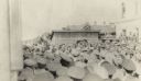
| Description: | Prime Minister Pandit Jawaharlal Nehru of India decending the stairs from an airplane at Truax Field. Nehru came to Madison to speak at the University of W... |

| Date: | 04 29 1950 |
|---|---|
| Description: | Second place spelling bee champion Dale Sorenson, left, receiving a $25 dollar check from Roy L. Matson, State Journal editor. Looking on are Dale's mother... |
| Date: | 1917 |
|---|---|
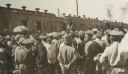
| Description: | Senator Elihu Root addressing Russian soldiers at Perm. Root is standing near the Imperial train that carried members of the Root Commission. |
| Date: | 1917 |
|---|---|
| Description: | Senator Elihu Root addressing Russian soldiers at Perm. Root is standing near the Imperial train that carried members of the Root Commission. |
| Date: | 11 27 1950 |
|---|---|
| Description: | Front cover of the menu for a dinner given by Nazrollah Entezam, President of the United Nations (UN) General Assembly during its fifth session and leader ... |
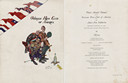
| Date: | 02 26 1942 |
|---|---|
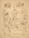
| Description: | Front cover and menu page from the program for the Third Annual Dinner of the Overseas Press Club of America for Anti-Axis Solidarity, with an illustration... |

| Date: | 1780 |
|---|---|
| Description: | Map of North and South America, showing the boundaries of colonial territories, cities, settlements, rivers, lakes, and Native American land. Particular em... |

| Date: | 1710 |
|---|---|
| Description: | Map of North America showing the European claims, Native American land and villages, rivers, lakes, cities, and notes on explorers, discoveries, and topogr... |

| Date: | 1719 |
|---|---|
| Description: | Map of North America showing land divisions between France, Spain, England, Sweden, Denmark and Holland. The map is detailed, labeling cities, forts, islan... |

| Date: | 1770 |
|---|---|
| Description: | Map of North America from the Great Lakes to the northern portion of South America. It shows cities, Native American land, mountains, swamps, lakes, rivers... |
If you didn't find the material you searched for, our Library Reference Staff can help.
Call our reference desk at 608-264-6535 or email us at: