 Filter: Categories of Wisconsin Historical Images
Filter: Subject of Harbors
Filter: Subject of political science
Filter: Subject of cities and towns
Filter: Categories of Wisconsin Historical Images
Filter: Subject of Harbors
Filter: Subject of political science
Filter: Subject of cities and towns
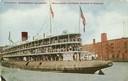
| Date: | 1912 |
|---|---|
| Description: | The passenger excursion vessel, "Christopher Columbus," entering harbor. Caption reads: "Steamship 'Christopher Columbus' (Whaleback), Entering Harbor at ... |
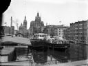
| Date: | |
|---|---|
| Description: | Elevated view of two Goodrich Line passenger ferries docked on the west bank of the Milwaukee River, north of the Clybourn Street bridge. The Pabst buildin... |
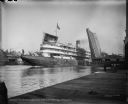
| Date: | 08 30 1906 |
|---|---|
| Description: | The excursion steamer "Christopher Columbus" passing through the Broadway Bridge in Milwaukee, Wisconsin. Caption on glass plate reads, "Steamer, Christoph... |

| Date: | 09 27 1942 |
|---|---|
| Description: | Labeled as a "freak" snowstorm. A boathouse takes up the majority of the image, with a flag flying over the boathouse. The lake is not frozen, but ice and... |

| Date: | 1907 |
|---|---|
| Description: | Text on front reads: "Racine, Wis. in 1850." Artist's rendering of the view of the harbor with sailing ships, sailboats, rowboats and canoes. The Main Stre... |
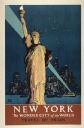
| Date: | 1934 |
|---|---|
| Description: | An original lithograph promoting both New York City as "the wonder city of the world," and train travel. Featuring the artist Adolph Treidler, the poster d... |
| Date: | |
|---|---|
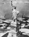
| Description: | Elevated view of the Statue of Liberty and surrounding buildings on Liberty Island. A large ship is docked at the island and the waters of the New York Upp... |
| Date: | |
|---|---|
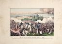
| Description: | A large color lithograph with caption of the battle in progress. |
| Date: | 1918 |
|---|---|
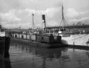
| Description: | View of ships moored in the harbor. Sign painted on the ship reads: "Brookline" and the barge next to the ship is loaded with railroad cars. "Atlantic Tran... |
| Date: | 1933 |
|---|---|
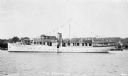
| Description: | View across water of the motor yacht "The Nellewood" at dock at Madeline Island on Lake Superior. A group of passengers sit in the bow area. The "Nellewood... |

| Date: | 1959 |
|---|---|
| Description: | Aerial view of the island of Cuba taken from a small plane. Part of the plane with a Cuban flag painted on it is in the frame, and the island with many bui... |
| Date: | 1897 |
|---|---|
| Description: | View from shoreline of replicas of the Niña, Pinta and Santa Maria docked in a harbor among many boats. |

| Date: | 1918 |
|---|---|
| Description: | Elevated view looking down gutter of roof towards the British volunteer forces parading in Archangel [Archangelsk], Russia right before they disembarked fr... |

| Date: | 1918 |
|---|---|
| Description: | Elevated view from roof of British volunteer forces parading in Archangel [Archangelsk], Russia right before they disembarked from the town. The crowd watc... |

| Date: | 1715 |
|---|---|
| Description: | A map of the countries and islands surrounding the Gulf of Mexico. The hand-colored borders separate the territories of England, France, Spain, and Holland... |

| Date: | 1720 |
|---|---|
| Description: | One of Herman Moll's most famous maps, often referred to as The Beaver Map for its elaborate engraved inset depicting and describing beavers building a dam... |

| Date: | 1715 |
|---|---|
| Description: | One of Herman Moll's most famous maps, often referred to as The Codfish Map, it shows rivers and portages, cities, Indian villages, wind directions, routes... |

| Date: | 1720 |
|---|---|
| Description: | This map of North America shows cities, rivers, lakes, and a few topographical features, complete with numerous descriptive blocks of text about expedition... |

| Date: | 1733 |
|---|---|
| Description: | This map of North America shows settlements, rivers, lakes, Native American land, trade winds, and numerous topographical features such as forests and moun... |

| Date: | 02 01 1919 |
|---|---|
| Description: | View from ship as a crowd on a pier is saying goodbye to "Espagne" as it is sailing away. Captioned: "The crowd at the pier as the 'Espagne' left for Borde... |
If you didn't find the material you searched for, our Library Reference Staff can help.
Call our reference desk at 608-264-6535 or email us at: