 Filter: Categories of Wisconsin Historical Images
Filter: Subject of Great Lakes
Filter: Year of 1900-1999
Filter: Year of 1950-1959
Filter: Categories of Wisconsin Historical Images
Filter: Subject of Great Lakes
Filter: Year of 1900-1999
Filter: Year of 1950-1959

| Date: | 07 1959 |
|---|---|
| Description: | Dickey Chapelle, photographer, on the same Milwaukee beach where she learned to swim as a young girl. She was covering "Operation Inland Seas" celebrating ... |

| Date: | 1956 |
|---|---|
| Description: | A map depicting the for systems of land description in Wisconsin, which include metes and bounds, U.S. System of Rectangular Surveys, Latitude and longitud... |

| Date: | 1952 |
|---|---|
| Description: | Map of the barley-growing regions of North America, published by the Rahr Malting Company, Manitowoc, Wisconsin, 1952. |

| Date: | 1951 |
|---|---|
| Description: | This map shows Ashland and Washburn harbors in shades of blue and yellow. Water depths shown by isolines and soundings, and relief is shown by contours. Th... |

| Date: | 01 06 1958 |
|---|---|
| Description: | View from jetty out towards Lake Michigan entrance to Ship Canal. A large tank, streetlamp and buildings are on the left. On the opposite jetty is a lighth... |

| Date: | 01 06 1958 |
|---|---|
| Description: | View of the Ship Canal from the Coast Guard station. There are pieces of machinery on the right, and a line of trees on the left. There is snow on the grou... |
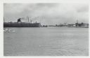
| Date: | 01 07 1958 |
|---|---|
| Description: | View across water to ship moored at a dock. Smoke is coming out of the smokestack. Industrial buildings are across the water on the right. |

| Date: | 12 10 1957 |
|---|---|
| Description: | Pleasure boat ramps, made of timber, on the south side of Racine Harbor. A man is walking in the snow near the ramps. There are piles of material along the... |

| Date: | 12 20 1957 |
|---|---|
| Description: | View across harbor from small boat ramp towards far shoreline. On the far shoreline is industrial machinery, piles of coal, and other buildings. |

| Date: | 12 10 1957 |
|---|---|
| Description: | View of harbor with pilings in the right foreground. There is a lighthouse on breakwaters in the distance. |

| Date: | 10 15 1956 |
|---|---|
| Description: | This map shows cities with improved harbors along the Great Lakes. A portion of Illinois, Michigan, Ohio, Ontario, and Quebec are also shown. A legend and... |

| Date: | 1957 |
|---|---|
| Description: | This map shows the straights and rivers that connect the Great Lakes, as well as the proposed channels that have been authorized but not at the time of the... |
| Date: | 1951 |
|---|---|
| Description: | This colored road map shows automobile roads in Wisconsin as well as portions of nearby states. Information on the quality and type of any road shown (pave... |

| Date: | 1955 |
|---|---|
| Description: | This colored road map shows automobile roads in Wisconsin as well as portions of nearby states. Information on the quality and type of any road shown (U.S.... |
| Date: | 1955 |
|---|---|
| Description: | This colored road map shows automobile roads in Wisconsin as well as portions of nearby states. Information on the quality and type of any road shown (pave... |

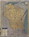
| Date: | 1956 |
|---|---|
| Description: | This colored road map shows automobile roads in Wisconsin as well as portions of nearby states. The map is organized such that a single map of Wisconsin is... |

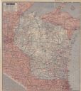
| Date: | 1957 |
|---|---|
| Description: | This colored road map shows automobile roads in Wisconsin as well as portions of nearby states. The map is organized such that a single map of Wisconsin is... |

| Date: | 1959 |
|---|---|
| Description: | This colored road map shows roads in Wisconsin as well as portions of nearby states. Information on the quality and type of any road shown (expressways, St... |
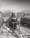
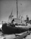
| Date: | 1955 |
|---|---|
| Description: | A tugboat, "Jane of Kimberly," is cradled out of the water for winter storage or repairs. Two other boats are cradled on each side. In the background are t... |
| Date: | 02 18 1958 |
|---|---|
| Description: | The SS Meteor, a Great Lakes cargo steamship of whaleback design, coming into harbor. The ship is covered with snow and ice and the surface of the l... |
If you didn't find the material you searched for, our Library Reference Staff can help.
Call our reference desk at 608-264-6535 or email us at: