 Filter: Categories of Wisconsin Historical Images
Filter: Subject of Fortification
Filter: Categories of Wisconsin Historical Images
Filter: Subject of Fortification

| Date: | |
|---|---|
| Description: | This map is pen-and-ink on tracing paper with a mounted legend and shows the Kickapoo River, Indian mounds, the 1st Fort Crawford, an Indian Agency, the si... |

| Date: | 1840 |
|---|---|
| Description: | This map shows a line of proposed construction for defending the north side of the canal against inundation from the Wisconsin River and location of Fort W... |

| Date: | 12 1958 |
|---|---|
| Description: | A soldier in Castro's forces at the battle for the village of LaMaya, Cuba. He is firing from a position known as "The Hole." |

| Date: | 1961 |
|---|---|
| Description: | Rear view of a soldier at a wall on the edge of the Vietnamese village of Binh Hung. A rifle and pack are hanging from a wooden post, and next to it is a s... |

| Date: | 1965 |
|---|---|
| Description: | View from rooftop of a blockaded street in Santo Domingo, Dominican Republic, seen from a U.S. Marine position. A large group of civilians, mainly women, s... |

| Date: | 1837 |
|---|---|
| Description: | This map shows the planned military posts/depots, roads, existing forts, rivers, and land assigned to various Indian tribes. Illinois, Mississippi, Arkansa... |
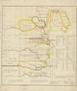
| Date: | 1836 |
|---|---|
| Description: | This map shows rivers, roads, military posts, and geographical locations by tribe. Includes treaty notes and tables of Indian population statistics by trib... |

| Date: | 1900 |
|---|---|
| Description: | This photostat of a manuscript map originally drawn in 1829 shows landownership, buildings, including Fort Howard and U.S. sawmill, swamps, public barns an... |

| Date: | 1862 |
|---|---|
| Description: | This map shows landownership on a military reserve, private claims, buildings (including Fort Howard and U.S. sawmill), swamps, public barns and fields, an... |

| Date: | 1900 |
|---|---|
| Description: | This map shows a proposed route of for a road linking military forts. The map also includes communities, lakes, and rivers. The map is accompanied by a rep... |

| Date: | 1900 |
|---|---|
| Description: | This photocopy map shows proposed buildings and building use at Fort Crawford. |

| Date: | 1900 |
|---|---|
| Description: | This photocopy map shows marshes, woods, buildings, and selected features including islands, mounds, old Fort Crawford, and "new site for a fort in questio... |

| Date: | 1839 |
|---|---|
| Description: | This map shows the geological makeup of the valley in red, yellow, and green, the Mississippi River, and the location of Fort Crawford. The geology on the ... |

| Date: | 1719 |
|---|---|
| Description: | Map of the Great Lakes and the St. Lawrence river showing French and English cities and villages, trading posts, Indian villages and tribes, portages, for... |
| Date: | 1917 |
|---|---|
| Description: | Poster featuring an illustration of a soldier with his gear, adjusting his helmet while standing behind sandbags. On his belt is a gas mask. Poster text re... |

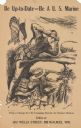
| Date: | 1917 |
|---|---|
| Description: | Poster featuring an illustration of two Marines corpsmen at a beach fort. One Marine is raising a U.S. flag while the other Marine is saluting. In the back... |
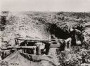
| Date: | 1915 |
|---|---|
| Description: | View of a military trench near Hecken in the Alsace region of northeastern France. |
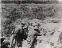
| Date: | 1917 |
|---|---|
| Description: | Two soldiers wearing combat uniforms and holding machine guns are in a trench with barbed wire in the background. The men are in a combat zone in France. |

| Date: | 1915 |
|---|---|
| Description: | Austrian soldiers shooting at an airplane somewhere in Galicia. |

| Date: | 1919 |
|---|---|
| Description: | Poster with an illustration of a British soldier sitting on a battlefield near a trench with barb wire among many destroyed trees at night. There are birds... |
If you didn't find the material you searched for, our Library Reference Staff can help.
Call our reference desk at 608-264-6535 or email us at: