Filter: Categories of Wisconsin Historical Images
Filter: Subject of Fortification
Filter: Reproduction Rights of For Sale
Filter: Categories of Wisconsin Historical Images
Filter: Subject of Fortification
Filter: Reproduction Rights of For Sale

| Date: | 1864 |
|---|---|
| Description: | Map of eastern Virginia and part of Maryland, showing engagements by crossed swords, fortifications surrounding Richmond, routes of the opposing armies fro... |

| Date: | 1865 |
|---|---|
| Description: | Detailed map of the southeastern United States showing fortifications, "movements of Genl. J.H. Wilson's Cavalry Corps," "pursuit of Hood" and the lines of... |

| Date: | 1862 |
|---|---|
| Description: | Map of southeastern Virginia indicating fortifications, towns, roads, railroads, drainage, and some vegetation. 2 sheets, each mounted on 1 sheet. |

| Date: | 1860 |
|---|---|
| Description: | A survey map of Wisconsin, southeastern Minnesota, and northern Iowa, showing the status of surveys, rivers, and lakes. The map also shows the locations of... |
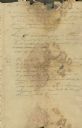
| Date: | 06 23 1832 |
|---|---|
| Description: | Document written by Ebenezer Brigham listing events at Fort Blue Mounds. |
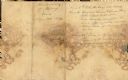
| Date: | 06 23 1832 |
|---|---|
| Description: | Document written by Ebenezer Brighman listing occurrences at Fort Blue Mounds. |

| Date: | 1847 |
|---|---|
| Description: | A hand-colored map that shows the area south and east of the Wisconsin and Fox Rivers, as well as a few landmarks just north of that area. The township gri... |
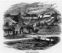
| Date: | 1853 |
|---|---|
| Description: | Stereograph of the interior of Fort Howard after its decommissioning in 1853. |

| Date: | 1816 |
|---|---|
| Description: | This is a photostat copy of a manuscript map in the National Archives showing a plan of Fort Howard and a view of its north side. Originally surveyed by Wi... |

| Date: | 1914 |
|---|---|
| Description: | This map is a photostat copy from the original 1829 map in the War Department. The map shows location of Fort Howard, lots, land claims of Jacques Porlier ... |

| Date: | 1887 |
|---|---|
| Description: | This 1887 manuscript map by Amidon G. Miller covers portions of the towns of Nelson and Stockholm in Pepin County, Wisconsin, as well as a portion of the T... |
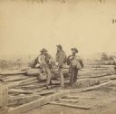
| Date: | 07 1863 |
|---|---|
| Description: | Stereograph of three Confederate soldiers captured during the Battle of Gettysburg. This photograph was taken by Mathew Brady a few days after the battle. ... |
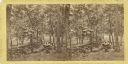
| Date: | 07 1863 |
|---|---|
| Description: | A stereograph made by Mathew Brady about two weeks after the battle of Gettysburg, showing his two assistants gazing eastward from the extreme right of the... |

| Date: | 1867 |
|---|---|
| Description: | This 1867 manuscript map by Increase Lapham shows the topography and geology of the Blue Mounds region in the Town of Brigham in Iowa County and the towns ... |

| Date: | 1911 |
|---|---|
| Description: | This hand-colored map is a 1911 copy of a map drawn by Gaspard-Joseph Chaussegros de Léry in 1730 showing the Fox River from its mouth at Green Bay to Lake... |

| Date: | 1972 |
|---|---|
| Description: | Ink on tracing paper. This map shows rivers, Prairie du Chien, site of Fort Crawford, Excelsior, Fort Andrew, Boscobel, Blue River, Orion, Muscoda, Castle ... |
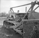
| Date: | 08 22 1943 |
|---|---|
| Description: | Corporal Eugene Cierzynski of Milwaukee, Wisconsin (left) instructs Corporal Edgar Hourscht of Trosky, Minnesota (right), on how to operate a D-8 Caterpill... |

| Date: | 01 22 1944 |
|---|---|
| Description: | Artillerymen of Battalion A are ready for an enemy attack in a gun pit, at Saidor, New Guinea (present day Papua New Guinea). A knife is standing point dow... |
If you didn't find the material you searched for, our Library Reference Staff can help.
Call our reference desk at 608-264-6535 or email us at: