 Filter: Categories of Wisconsin Historical Images
Filter: Subject of Formations (Geology)
Filter: Year of 1800-1899
Filter: Categories of Wisconsin Historical Images
Filter: Subject of Formations (Geology)
Filter: Year of 1800-1899
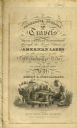
| Date: | 1820 |
|---|---|
| Description: | Narrative Journal of Travels from Detroit Northwest through the Great chain of American Lakes to the sources of the Mississippi River in the year 1820. Ill... |

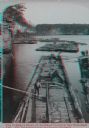
| Date: | 1890 |
|---|---|
| Description: | Elevated view of men working on lumber rafts on the Wisconsin River. |
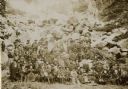
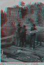
| Date: | 09 16 1896 |
|---|---|
| Description: | Outdoor group portrait of a reunion of the Iron Brigade, veterans of the Civil War, and their families at Devil's Lake, Wisconsin. The couple seated in... |
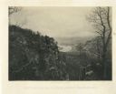
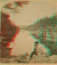
| Date: | 1866 |
|---|---|
| Description: | Cliffs along Lu-la Lake. A waterfall is in the background. Plate 15 |
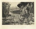
| Date: | 1866 |
|---|---|
| Description: | Elevated view of the Chattanooga Valley, with a river in the far background. A cliff face and trees are in the foreground. Plate 14 |
| Date: | 1886 |
|---|---|
| Description: | Stereograph view of several groups of men on rafts loaded with felled trees. |
| Date: | 1886 |
|---|---|
| Description: | Stereograph of a man on a lumber raft steering the raft through the rapids in the Wisconsin Dells. |
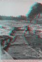
| Date: | 1886 |
|---|---|
| Description: | Stereograph of four raftsmen shipping an oar in the Dells. |
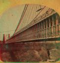
| Date: | 1877 |
|---|---|
| Description: | An A.L. Dahl photograph, one of "Two different side views of the Suspension Bridge," from the series "Niagara Falls and Suspension Bridge" as mentioned in ... |
| Date: | 1880 |
|---|---|
| Description: | Stereograph of the Dalles and the Saint Croix River with man in the foreground. |

| Date: | 1844 |
|---|---|
| Description: | A hand-colored map and chart showing a geological cross-section from Rockingham, in present-day Scott County, Iowa, through Blue Mounds to the Wisconsin Ri... |

| Date: | 1852 |
|---|---|
| Description: | Hand-colored maps and a series of geological cross sections of the Mississippi River between the Falls of St. Anthony and the mouth of the Wisconsin River ... |

| Date: | 1855 |
|---|---|
| Description: | This map shows counties, cities, rivers, canals, lakes, railroads, common roads, county towns, townships, villages, and post offices. The map includes part... |
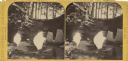
| Date: | 1885 |
|---|---|
| Description: | Stereograph of a sailboat in Excursion Cave, on Hemlock Island of the Apostle Islands. A man can be seen sitting in the boat. |
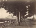
| Date: | 1890 |
|---|---|
| Description: | View down road lined with trees in Egypt. A group of Egyptians are standing and sitting between the trees and the river, and travelers on the road are walk... |
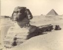
| Date: | 1890 |
|---|---|
| Description: | The Sphinx at Giza in Egypt. Three men are standing or sitting on the shoulder of the Sphinx, and several men are sitting in the shade below with two camel... |
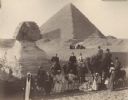
| Date: | 1896 |
|---|---|
| Description: | A group portrait of Violet Lee Dousman (back row, 3rd from left) and her fellow travelers, guides and Egyptians on a trip to Giza, Egypt. Five people are r... |

| Date: | 1864 |
|---|---|
| Description: | A geological map of Wisconsin that shows the locations of different rock deposits such as limestone, sandstone, shale, plutonic and the Penokee Iron Range.... |

| Date: | 1882 |
|---|---|
| Description: | A geological map of northern Wisconsin showing the locations of different soil types in the state such as sandy soil, sandy loam, prairie loam, clayey loam... |

| Date: | 1847 |
|---|---|
| Description: | A hand-colored map that shows the area south and east of the Wisconsin and Fox Rivers, as well as a few landmarks just north of that area. The township gri... |
If you didn't find the material you searched for, our Library Reference Staff can help.
Call our reference desk at 608-264-6535 or email us at: