 Filter: Categories of Wisconsin Historical Images
Filter: Subject of Formations (Geology)
Filter: Year of 1800-1899
Filter: Year of 1850-1859
Filter: Subject of land
Filter: Categories of Wisconsin Historical Images
Filter: Subject of Formations (Geology)
Filter: Year of 1800-1899
Filter: Year of 1850-1859
Filter: Subject of land

| Date: | 1852 |
|---|---|
| Description: | Illustration of the Ojibwa, the Sacs, and Foxes battling from canoes on the water. |

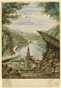
| Date: | 1854 |
|---|---|
| Description: | Drawing of the Porcupine Mountains on Lake Superior. A deer is standing in the lake drinking water. A man is on the rock ledge above the shoreline and is a... |
| Date: | 1857 |
|---|---|
| Description: | Business with Frank Leslie's Illustrated Newspaper took Hölzlhuber to New York, and from there he also visited Philadelphia, Baltimore, and Washingt... |
| Date: | 1851 |
|---|---|
| Description: | Owen Geological Map of Wisconsin. |

| Date: | 1852 |
|---|---|
| Description: | Hand-colored maps and a series of geological cross sections of the Mississippi River between the Falls of St. Anthony and the mouth of the Wisconsin River ... |

| Date: | 1855 |
|---|---|
| Description: | This map shows counties, cities, rivers, canals, lakes, railroads, common roads, county towns, townships, villages, and post offices. The map includes part... |

| Date: | 1853 |
|---|---|
| Description: | Engraved image of a boat being towed through a canal at Little Falls by a team of horses. A small town is in the background. |

| Date: | 09 01 1856 |
|---|---|
| Description: | This map is pen-and-ink and shows farm lots, other lots of land sectioned by acres, bluffs, and a coulee. Also included are notations in pencil and blue in... |

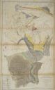
| Date: | 1858 |
|---|---|
| Description: | This map shows the depth of the West Channel and the different types of minerals that make up the floor bed. The steamboat range station is labeled. A note... |
If you didn't find the material you searched for, our Library Reference Staff can help.
Call our reference desk at 608-264-6535 or email us at: