 Filter: Categories of Wisconsin Historical Images
Filter: Subject of Formations (Geology)
Filter: Year of 1800-1899
Filter: Subject of cities and towns
Filter: Categories of Wisconsin Historical Images
Filter: Subject of Formations (Geology)
Filter: Year of 1800-1899
Filter: Subject of cities and towns

| Date: | 1890 |
|---|---|
| Description: | View looking down railroad tracks towards the Chicago, Milwaukee and St. Paul Railroad locomotive #240, a type 4-4-0. On the right is a steep, rocky bank, ... |
| Date: | 1890 |
|---|---|
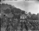
| Description: | Woman standing on second story porch and boy standing in vineyard behind small residence. A bluff is in the background. |
| Date: | 1857 |
|---|---|
| Description: | Business with Frank Leslie's Illustrated Newspaper took Hölzlhuber to New York, and from there he also visited Philadelphia, Baltimore, and Washingt... |

| Date: | 1878 |
|---|---|
| Description: | Kilbourn Bridge at the Wisconsin Dells, Wisconsin. A locomotive is pulling railroad cars over the bridge. |
| Date: | 1872 |
|---|---|
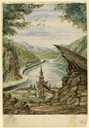
| Description: | An excerpt from "Picturesque America," ed. Bryant, (1872). |
| Date: | 1890 |
|---|---|
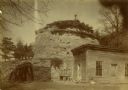
| Description: | Old Uncle Billy Johnson home at Governor Phillip's house, about six miles north of Prairie du Sac near highway 12. Portion of house, rock formation in back... |

| Date: | 1839 |
|---|---|
| Description: | Shows locations of cities, towns, villages, post hamlets, canals, rail and stage roads. Includes table of steamboat routes and distances; vignette of "Maid... |

| Date: | 1887 |
|---|---|
| Description: | Benedict & Co. engineers. As shown by development to March 1st 1887. Inset: Map of northern Wisconsin showing location of range. Lands in red. |
| Date: | 1866 |
|---|---|
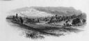
| Description: | Elevated view of the Chattanooga Valley, with a river in the far background. A cliff face and trees are in the foreground. Plate 14 |

| Date: | 1847 |
|---|---|
| Description: | A hand-colored map that shows the area south and east of the Wisconsin and Fox Rivers, as well as a few landmarks just north of that area. The township gri... |

| Date: | 1874 |
|---|---|
| Description: | This map of Wisconsin shows cities, counties, railroads already completed and railroads projected, and geological makeup of the land such as lakes. |

| Date: | 1869 |
|---|---|
| Description: | This geological map shows the township grid, counties, cities and villages, rivers, lakes, railroads, and roads. Barron County is still labeled Dallas Coun... |

| Date: | 1853 |
|---|---|
| Description: | Engraved image of a boat being towed through a canal at Little Falls by a team of horses. A small town is in the background. |

| Date: | 1895 |
|---|---|
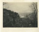
| Description: | Elevated view from bluffs, looking north-east toward Lake City, Minnesota and Lake Pepin of the Mississippi River. |
| Date: | 1890 |
|---|---|
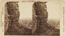
| Description: | Stereograph view from the bluffs looking down over a town. A man is standing on the edge of the side of the formation, about halfway up, above treeline, an... |

| Date: | 09 01 1856 |
|---|---|
| Description: | This map is pen-and-ink and shows farm lots, other lots of land sectioned by acres, bluffs, and a coulee. Also included are notations in pencil and blue in... |

| Date: | 1847 |
|---|---|
| Description: | This map identifies surveyed areas of the Upper Peninsula and shows lakes, rivers, and islands in portions of Wisconsin, Minnesota, Michigan, and upper Can... |

| Date: | 1883 |
|---|---|
| Description: | This map shows the geology of areas in Montana, the Dakotas, Nebraska, Wyoming, Idaho, Colorado, Kansas, Arizona, New Mexico, and Utah. Map also shows lake... |

| Date: | 10 1891 |
|---|---|
| Description: | This blueprint map shows land ownership and buildings. Text below the title reads: "The La Crosse Heights include the ridge of land with the spurs projecti... |

| Date: | 1839 |
|---|---|
| Description: | This map shows the geological makeup of the valley in red, yellow, and green, the Mississippi River, and the location of Fort Crawford. The geology on the ... |
If you didn't find the material you searched for, our Library Reference Staff can help.
Call our reference desk at 608-264-6535 or email us at: