 Filter: Categories of Wisconsin Historical Images
Filter: Subject of Formations (Geology)
Filter: Subject of indian reservations
Filter: Categories of Wisconsin Historical Images
Filter: Subject of Formations (Geology)
Filter: Subject of indian reservations
| Date: | |
|---|---|
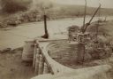
| Description: | The head gate at the Big Horn Ditch on the Crow Reservation in northeast Wyoming. Men are working with cranes near a tent with a chimney spewing out smoke. |
| Date: | |
|---|---|
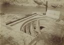
| Description: | The head gate at the Big Horn Ditch on the Crow Reservation in northeast Wyoming. |
| Date: | 1905 |
|---|---|
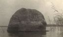
| Description: | Rock near the principal village of the Chippewa Indian Reservation. |
| Date: | |
|---|---|
| Description: | Postcard of Route 55 Menominee Indian reservation, Dells of Wolf River. |

| Date: | 1847 |
|---|---|
| Description: | A hand-colored map that shows the area south and east of the Wisconsin and Fox Rivers, as well as a few landmarks just north of that area. The township gri... |

| Date: | 1911 |
|---|---|
| Description: | This 1911 map of the geology of northern Wisconsin between Superior and Hurley was published by the Wisconsin Geological and Natural History Survey in Fred... |

| Date: | |
|---|---|
| Description: | A map of the Apostle Islands, including the harbor of Bayfield and its surroundings. |

| Date: | 1950 |
|---|---|
| Description: | A young woman is posing sitting on a boulder on the shoreline along a river rapids. She is holding a walking stick and is wearing a romper. The description... |
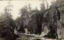
| Date: | |
|---|---|
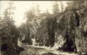
| Description: | The Dells of the Wolf River in the Menominee Indian Reservation. |
If you didn't find the material you searched for, our Library Reference Staff can help.
Call our reference desk at 608-264-6535 or email us at: