 Filter: Categories of Wisconsin Historical Images
Filter: Subject of Ferries
Filter: Year of 1900-1999
Filter: Reproduction Rights of For Sale
Filter: Categories of Wisconsin Historical Images
Filter: Subject of Ferries
Filter: Year of 1900-1999
Filter: Reproduction Rights of For Sale

| Date: | 1957 |
|---|---|
| Description: | This colored road map shows automobile roads in Wisconsin as well as portions of nearby states. The map is organized such that a single map of Wisconsin is... |

| Date: | 1959 |
|---|---|
| Description: | This colored road map shows roads in Wisconsin as well as portions of nearby states. Information on the quality and type of any road shown (expressways, St... |

| Date: | 1960 |
|---|---|
| Description: | This colored road map shows roads in Wisconsin as well as portions of nearby states. Information on the quality and type of any road shown can be found in ... |

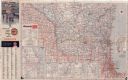
| Date: | 1962 |
|---|---|
| Description: | This colored road map shows roads in Wisconsin as well as portions of nearby states. The map is organized such that a single map of Wisconsin is divided on... |
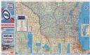
| Date: | 1962 |
|---|---|
| Description: | This colored road map shows roads in Wisconsin as well as portions of nearby states. The map is organized such that a single map of Wisconsin is divided on... |

| Date: | 1963 |
|---|---|
| Description: | This colored road map shows automobile roads in Wisconsin as well as portions of nearby states. The map is organized such that a single map of Wisconsin is... |
| Date: | 1963 |
|---|---|
| Description: | This colored road map shows automobile roads in Wisconsin as well as portions of nearby states. The map is organized such that a single map of Wisconsin is... |

| Date: | 1965 |
|---|---|
| Description: | This colored road map shows automobile roads in Wisconsin as well as portions of nearby states. Information on the quality and type of any road shown (inte... |
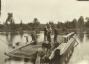
| Date: | 1907 |
|---|---|
| Description: | The travelers, including Diadem, taking the ferry at Pansy. |

| Date: | 06 1971 |
|---|---|
| Description: | The Merrimac Ferry hauling cars across the Wisconsin River. A bridge across the river is in the background behind the ferry. |

| Date: | 08 10 1929 |
|---|---|
| Description: | Display of miniature of truck that crossed the Sahara. There are maps of part of Europe and the continent of Africa, and signs on the display read, in part... |
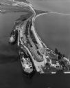
| Date: | 09 17 1948 |
|---|---|
| Description: | Aerial view of two Lake Michigan ferries tied up at harbor slips. The eastern terminus of the Green Bay Route was the Lake Michigan port city of Kewaunee. ... |
If you didn't find the material you searched for, our Library Reference Staff can help.
Call our reference desk at 608-264-6535 or email us at: