 Filter: Categories of Wisconsin Historical Images
Filter: Subject of Farms
Filter: Year of 1800-1899
Filter: Year of 1850-1859
Filter: Categories of Wisconsin Historical Images
Filter: Subject of Farms
Filter: Year of 1800-1899
Filter: Year of 1850-1859

| Date: | 1856 |
|---|---|
| Description: | The Ludemann's [also spelled Lueddemann] farm had been cultivated since the early 1850s by Mr. Ludemann, "a very pleasant Saxon with his very pleasant wife... |
| Date: | 1858 |
|---|---|
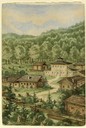
| Description: | Hölzlhuber located this farm at about three German miles from Stevens Point. The region's soil was quite fertile. A wooden dwelling house stood in the mids... |

| Date: | 1858 |
|---|---|
| Description: | On a very hot day in August 1858 Hölzlhuber visited the farm of Jack Smith, an Irishman who had immigrated to Canada eleven years previously with his wife ... |
| Date: | 1859 |
|---|---|
| Description: | Ranzer's prosperous farm was hewn out of the forest rather than the prairie. This was "of course more difficult" and needed hired help to fell and burn the... |

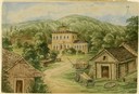
| Date: | 1858 |
|---|---|
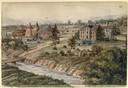
| Description: | Hofmann and three sons had emigrated in 1848 from the Rhine region to northern Wisconsin. Initially they had no neighbors for a distance of four to five ho... |
| Date: | 1858 |
|---|---|
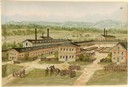
| Description: | Friedrich Flersheim immigrated from Mecklenburg to Illinois in the early 1850s, and after farming for a time built this distillery on the Black River in Wi... |
| Date: | 1859 |
|---|---|
| Description: | Mr. Klaner, who had just come from Elberfeld to Canada in 1858, purchased this farm and worked it with his wife and children. Initially they were plagued b... |
| Date: | 1858 |
|---|---|
| Description: | Beginning at Odanah just south of Lake Superior, Hölzlhuber and several fur trappers used an Indian trail to travel upstream through extensive wild forest.... |

| Date: | 1858 |
|---|---|
| Description: | The fertillity of the soil in America and Canada, especially in Wisconsin, was the attraction for most European immigrants. The vast amount of land and the... |
| Date: | 1859 |
|---|---|
| Description: | Due to rainy weather, Hölzlhuber stayed a night in the home of Heinrich Cordes, who had purchased his land from an Irishman and built "a pretty brick house... |
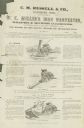
| Date: | 1859 |
|---|---|
| Description: | Handbill for W.K. Miller's Iron Harvester, a combined reaper and mower manufactured by C.M. Russell & Company. Features three line drawings of machines. |
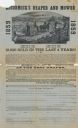
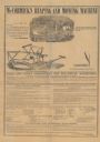
| Date: | 1859 |
|---|---|
| Description: | Flyer and order form advertising McCormick's Reaper and Mower. Features the headline "15,000 sold in the last 4 years" under an illustration of the reaper... |
| Date: | 1858 |
|---|---|
| Description: | Directions for putting together and operating McCormick's Reaping and Mowing Machine. Features illustrations of the machine in use in the field and alone. ... |
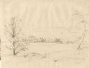
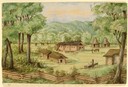
| Date: | 1852 |
|---|---|
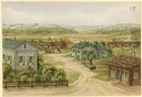
| Description: | Rural landscape with farm buildings seen from across a field and framed by trees. |

| Date: | 1854 |
|---|---|
| Description: | Brightly-colored map exhaustively marks the townships, County Towns and villages of Wisconsin. It also shows rivers, canals, railroads, and plank roads. Ea... |

| Date: | 1855 |
|---|---|
| Description: | Drawn seven years after Wisconsin entered statehood, this map shows the counties, cities, towns, rivers and lakes in the entire state. The map includes a c... |

| Date: | 1855 |
|---|---|
| Description: | This map is ink, pencil, and color on paper and shows property owners, a cemetery, farms, hotels, roads, a dike and on the back are additional notes. Notes... |

| Date: | 1857 |
|---|---|
| Description: | This map shows lots and streets and includes pencil manuscript notations on the front and certification statements on the reverse. The top left margin read... |

| Date: | 09 01 1856 |
|---|---|
| Description: | This map is pen-and-ink and shows farm lots, other lots of land sectioned by acres, bluffs, and a coulee. Also included are notations in pencil and blue in... |

| Date: | 1855 |
|---|---|
| Description: | This map shows streets and lots. The right side of the map includes notes on widths of streets and certifications. The top right reads: "Parish's Addition ... |
If you didn't find the material you searched for, our Library Reference Staff can help.
Call our reference desk at 608-264-6535 or email us at: