 Filter: Categories of Wisconsin Historical Images
Filter: Subject of Farms
Filter: County of Sawyer
Filter: Categories of Wisconsin Historical Images
Filter: Subject of Farms
Filter: County of Sawyer

| Date: | 1919 |
|---|---|
| Description: | This is a collection of three hand-colored plat maps. One map is a plat plan and includes annotations and an index that shows public land, business, indust... |

| Date: | 12 1910 |
|---|---|
| Description: | Exterior view of Deitz cabin and barn, fences, and other outbuildings in winter, about two weeks after shooting of deputy. No members of Deitz family were ... |

| Date: | 1909 |
|---|---|
| Description: | Map of Sawyer County with an advertisement for land sales through Fuley & Quail of Hayward, Wisconsin. There is a small inset map of railroads accessible i... |
| Date: | 1910 |
|---|---|
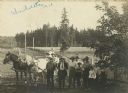
| Description: | Uhrenholdt family on the family farm in Seeley. |
| Date: | |
|---|---|
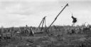
| Description: | A group of men remove a large stump with the help of horses and a winch on the family farm. |

| Date: | 1898 |
|---|---|
| Description: | This 1898 map of Sawyer County, Wisconsin, shows the township and range system, sections, roads, farm houses, camps, school houses, dams, bridges, Indian r... |

| Date: | 1902 |
|---|---|
| Description: | This 1902 map of the eastern portion of Sawyer County, Wisconsin, shows the township and range system, sections, roads, farm houses, camps, school houses, ... |
If you didn't find the material you searched for, our Library Reference Staff can help.
Call our reference desk at 608-264-6535 or email us at: