 Filter: Categories of Wisconsin Historical Images
Filter: Subject of Farmhouses
Filter: Subject of transportation
Filter: Subject of water
Filter: Categories of Wisconsin Historical Images
Filter: Subject of Farmhouses
Filter: Subject of transportation
Filter: Subject of water
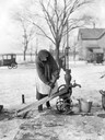
| Date: | 04 1923 |
|---|---|
| Description: | A bundled-up woman hand pumps water from a well into a pail. The ground is covered with ice and snow. Two cars and a farmhouse are in the background. |
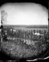
| Date: | |
|---|---|
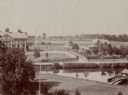
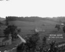
| Description: | View from hill over a valley dotted with farmsteads and a meandering stream in the foreground. A group of three or four people are posing at the opposite s... |
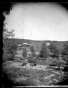
| Date: | |
|---|---|
| Description: | Elevated view of Andrew Amundsen's farm. A man with horses is at a well in the foreground. The well utilizes a well sweep. A barn, house and granary are on... |

| Date: | 1856 |
|---|---|
| Description: | The Ludemann's [also spelled Lueddemann] farm had been cultivated since the early 1850s by Mr. Ludemann, "a very pleasant Saxon with his very pleasant wife... |
| Date: | 1858 |
|---|---|
| Description: | Hölzlhuber located this farm at about three German miles from Stevens Point. The region's soil was quite fertile. A wooden dwelling house stood in the mids... |

| Date: | 1858 |
|---|---|
| Description: | On a very hot day in August 1858 Hölzlhuber visited the farm of Jack Smith, an Irishman who had immigrated to Canada eleven years previously with his wife ... |
| Date: | |
|---|---|
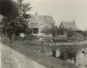
| Description: | Elevated view of barn and farmer's house of John Bass. |

| Date: | |
|---|---|
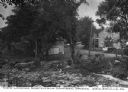
| Description: | View of a country farmhouse and rural road. A covered bridge and dam can be seen nearby. Text on photograph reads: "N.H. McQuiston & Son." |

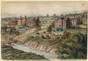
| Date: | |
|---|---|
| Description: | Elevated view of mill pond and homes along the opposite shoreline. A person is standing at the shoreline in the foreground. Caption reads, "Mill Pond, Mill... |
| Date: | |
|---|---|
| Description: | View looking north from a covered bridge, including a rocky stream-bed and a tree-lined dirt road with houses and other wooden buildings. Caption reads, "V... |
| Date: | |
|---|---|
| Description: | A farm boy is riding the "hay-fork horse" as the farmer is loading hay into the barn during haying time in July. |
| Date: | 1980 |
|---|---|
| Description: | Farmers work cooperatively with their horse teams on silo-filling activities early in autumn. Rows of green forage are created in the fields and carried to... |

| Date: | |
|---|---|
| Description: | Colorized postcard of the horseshoe curve of railroad tracks. Elevated view of the railroad tracks with train snaking past a farmhouse and a bridge suspend... |
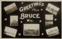
| Date: | 05 15 1909 |
|---|---|
| Description: | Photographic postcard of a poster promoting Bruce with seven photographs. The fairgrounds, Main Street, farm scene, Catholic Church, Chippewa River bridge,... |
| Date: | |
|---|---|
| Description: | Elevated view of farmland. In the bottom-left center, there is a structure with a bell tower near a dirt road. In the center there is a similar building. T... |
| Date: | 09 09 1922 |
|---|---|
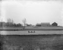
| Description: | The farmhouse of the Wetherby Cranberry Company. At the time the farmhouse was owned by H. Kissinger. In the foreground is the corner of the water reservoi... |

| Date: | 1944 |
|---|---|
| Description: | Continental Transportation Lines, Inc. operating an International truck tractor on an urban highway. A bridge, houses and industrial buildings are in the b... |
| Date: | 05 1900 |
|---|---|
| Description: | View of the Herman Backhaus farm buildings from across the Rock River. Four people are sitting in a rowboat. Other people are standing along the shoreline ... |

| Date: | 1897 |
|---|---|
| Description: | This 1897 map of Sawyer County, Wisconsin, shows the township and range system, sections, roads, farm houses, camps, school houses, dams, bridges, Indian r... |

| Date: | 1902 |
|---|---|
| Description: | This 1902 map of the eastern portion of Sawyer County, Wisconsin, shows the township and range system, sections, roads, farm houses, camps, school houses, ... |
If you didn't find the material you searched for, our Library Reference Staff can help.
Call our reference desk at 608-264-6535 or email us at: