 Filter: Categories of Wisconsin Historical Images
Filter: Subject of Exploration
Filter: Subject of recreation
Filter: Categories of Wisconsin Historical Images
Filter: Subject of Exploration
Filter: Subject of recreation
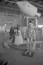
| Date: | 1965 |
|---|---|
| Description: | A traveling display about the NASA manned space program on exhibit at Austin Straubel Airport. Included in the exhibit is a model of a space capsule and a ... |

| Date: | 1893 |
|---|---|
| Description: | Front and back covers of an advertising brochure for the New Empire line of mowers, reapers and grain binders manufactured by J.F. Seiberling & Company. Th... |
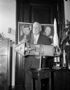
| Date: | 09 14 1962 |
|---|---|
| Description: | Senator Alexander Wiley posing with a cutaway model of an Apollo rocket. Behind him on a wall are portraits of Dwight D. Eisenhower and John F. Kennedy. |

| Date: | 10 23 1962 |
|---|---|
| Description: | Senator Alexander Wiley posing with a model of a missile. Near him on the desk are an American Flag and a globe. |
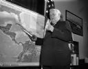
| Date: | 10 24 1962 |
|---|---|
| Description: | Senator Alexander Wiley posing with a model of a missile pointed at a map of Cuba. |
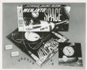
| Date: | |
|---|---|
| Description: | The board game for the television show Men Into Space. It includes game pieces, trivia cards, a game board, and a spinner. |

| Date: | 1715 |
|---|---|
| Description: | One of Herman Moll's most famous maps, often referred to as The Codfish Map, it shows rivers and portages, cities, Indian villages, wind directions, routes... |

| Date: | 1790 |
|---|---|
| Description: | An updated and corrected version of Robert de Vaugondy's 1750 map "Amérique Septentrionale: Dressée sur les Relations les Plus Modernes des Voyageurs et Na... |

| Date: | 1759 |
|---|---|
| Description: | Map of North and South America showing regions, colonies, cities and settlements, rivers, lakes, and Native American land. Near the bottom left an inset ma... |

| Date: | 1759 |
|---|---|
| Description: | Map of north eastern Canada and parts of New England, showing settlements, cities, portages, Native American land, mountains, lakes, and rivers. The unusua... |

| Date: | 1718 |
|---|---|
| Description: | Map of the Southern portion of North America from New Mexico to Florida and south from Lake Erie. It shows borders, cities, settlements, Native American la... |

| Date: | 1720 |
|---|---|
| Description: | Detailed, ornate, and comprehensive map of America from the east coast to present day Texas. Numerous features appear throughout the map, including Native ... |
If you didn't find the material you searched for, our Library Reference Staff can help.
Call our reference desk at 608-264-6535 or email us at: