 Filter: Categories of Wisconsin Historical Images
Filter: Subject of Engraving
Filter: Subject of women
Filter: Categories of Wisconsin Historical Images
Filter: Subject of Engraving
Filter: Subject of women

| Date: | 05 27 1934 |
|---|---|
| Description: | A sensational newspaper article about a newlywed couple encountering a sea serpent which resembles the Loch Ness monster. |

| Date: | 04 29 1934 |
|---|---|
| Description: | An illustrated, sensational article about giant robots replacing soldiers in fighting wars. |

| Date: | |
|---|---|
| Description: | Illustration from an unknown book. At the top is a portrait of beekeeper Anton Jansha (1734-1773) and German text in a cartouche below his name. The bottom... |

| Date: | 1570 |
|---|---|
| Description: | Frontispiece for Abraham Ortelius' Theatrum Orbis Terrarum, published in 1570, and considered the first modern atlas. Title is surrounded by four figures r... |

| Date: | 1720 |
|---|---|
| Description: | Double hemispherical world map showing routes of Tasman, Magellan, Mendana, etc. Relief shown pictorially. Title in oak wreath cartouche. Map between four ... |

| Date: | 1696 |
|---|---|
| Description: | Engraved and hand-colored map of Ethiopia, from Blaeu's General Atlas. Map title is framed by a man and a woman, both wearing head turbans, who are standin... |
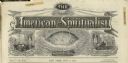
| Date: | 1872 |
|---|---|
| Description: | Engraved masthead for The American Spiritualist depicting a seance over the word "phenomenal," a globe over the word "scientific," and a man at a de... |
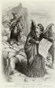
| Date: | 02 17 1872 |
|---|---|
| Description: | Political cartoon depicting a woman on a rocky path carrying two children and a drunken husband on her back being tempted by Victoria Woodhull depicted as ... |

| Date: | 1883 |
|---|---|
| Description: | Quarter-length portrait of Victoria Woodhull. The drawing was done during her marriage to John Biddulph Martin. |

| Date: | 1877 |
|---|---|
| Description: | Engraving of the Peck Cabin, after the painting by Mrs. E.E. Bailey. Caption at bottom reads: "First House in Madison. 1837." |

| Date: | 1703 |
|---|---|
| Description: | Map of the Golf of Mexico and surrounding countries from the Great Lakes down to the northern most parts of South America. L'Isle labels cities, towns, and... |

| Date: | 1746 |
|---|---|
| Description: | Map of North America from the southern portion of James Bay to Florida. It shows the colonies, cities, Native American land, and topological and geographic... |

| Date: | 1758 |
|---|---|
| Description: | This map of the north-west hemisphere shows the cities, lakes, rivers, mountains, and political borders. In the upper left corner sits a decorative cartouc... |

| Date: | 1627 |
|---|---|
| Description: | Map of North and South America showing settlements, rivers, lakes, mountains, islands and regions of the western hemisphere. It includes an inset map of Gr... |

| Date: | 1630 |
|---|---|
| Description: | One of the few maps by Dutch cartographer Willem Blaeu depicting the Americas, this map shows regions, settlements, islands, mountains, forests, rivers, an... |

| Date: | 1685 |
|---|---|
| Description: | A detailed map of the western hemisphere showing cities, settlements, Native American land, rivers, lakes, mountains, the Great Lakes, and California as an... |

| Date: | 1780 |
|---|---|
| Description: | Map of North and South America, showing the boundaries of colonial territories, cities, settlements, rivers, lakes, and Native American land. Particular em... |

| Date: | 1636 |
|---|---|
| Description: | Map of North America, divided into regions, and showing some rivers, lakes, settlements, cities, mountains, and Native American land. Of the Great Lakes on... |

| Date: | 1684 |
|---|---|
| Description: | Map of North America showing some colonies, cities, rivers, lakes, and Native American land. Ship routes spread across both oceans, including one decorated... |

| Date: | 1683 |
|---|---|
| Description: | Map of the north east coast of North America showing islands, regions, Native American land, bays, and a few European settlements. The Great Lakes appear i... |
If you didn't find the material you searched for, our Library Reference Staff can help.
Call our reference desk at 608-264-6535 or email us at: