 Filter: Categories of Wisconsin Historical Images
Filter: Subject of Engraving
Filter: Subject of water
Filter: Categories of Wisconsin Historical Images
Filter: Subject of Engraving
Filter: Subject of water
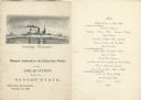
| Date: | 11 26 1898 |
|---|---|
| Description: | Menu for a "Banquet tendered by the Union Iron Works to the Delegation from the Badger State" given at the Palace Hotel, with an etching of the Battleship ... |

| Date: | 1698 |
|---|---|
| Description: | An illustration of two men looking out at Niagara Falls. The Niagara Falls in Jean Louis Hennepin’s A new discovery of a vast country in America (London: M... |

| Date: | 05 27 1934 |
|---|---|
| Description: | A sensational newspaper article about a newlywed couple encountering a sea serpent which resembles the Loch Ness monster. |
| Date: | 1840 |
|---|---|
| Description: | Sod-breaker and five yoke of oxen plowing in front of the “Old Cottage Inn.” In the foreground a boat is on the shoreline. |
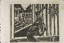
| Date: | 1937 |
|---|---|
| Description: | Linoleum cut engraved view of men building a log cabin. One man carries a log in the background near a lake or river, while another man nails a log held in... |

| Date: | 1720 |
|---|---|
| Description: | Double hemispherical world map showing routes of Tasman, Magellan, Mendana, etc. Relief shown pictorially. Title in oak wreath cartouche. Map between four ... |

| Date: | 1712 |
|---|---|
| Description: | Engraved double-hemispherical world map by Moll, included in his atlas The world described, or, A new and correct sett of maps: shewing the kingdoms and st... |

| Date: | 1696 |
|---|---|
| Description: | Engraved and hand-colored map of Ethiopia, from Blaeu's General Atlas. Map title is framed by a man and a woman, both wearing head turbans, who are standin... |

| Date: | 1798 |
|---|---|
| Description: | Engraved and hand-colored map of Egypt. Map title appears on bottom left as a carving in stone next ... |

| Date: | 1740 |
|---|---|
| Description: | Engraved and hand-colored map of the Iberian peninsula as a theater of war during the War of the Spanish Succession (1701-1714). The map is dedicated to Ki... |

| Date: | 1785 |
|---|---|
| Description: | Map of part of North America engraved and hand-colored (the light brown design is a superposition of the map and cartouche derived from the oxidation of th... |
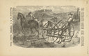
| Date: | 1880 |
|---|---|
| Description: | Front page of booklet with an engraving of a man with a team of two horses in a field with the "Celebrated Gorham Sulky Cultivator." |
| Date: | 1856 |
|---|---|
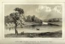
| Description: | Lithographic view of Four Legs Village at the outlet of Lake Winnebago. There are is a person in a canoe on the river and a large tree in the foreground. S... |
| Date: | 1856 |
|---|---|
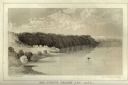
| Description: | Lithographic view of the Grande Chute Falls on the Fox River. There is a tent on the shore on the right. |
| Date: | 1856 |
|---|---|
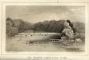
| Description: | Lithographic view of a man in a canoe on Big-Foot's Lake (modern day Lake Geneva) with a small settlement on a bluff overlooking the lake. A group of birds... |
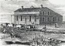
| Date: | 1856 |
|---|---|
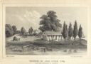
| Description: | Lithograhic view of the residence of John Kinzie on the bank of the Chicago River at the mouth of Lake Michigan. The residence consists of a house with a f... |

| Date: | |
|---|---|
| Description: | Letterhead of Johnson & Melaas, merchant tailors and cloth dealers, "Buyers of wool and Wisconsin leaf tobacco," with an engraving of a waterfront view of ... |

| Date: | 1877 |
|---|---|
| Description: | Engraving of the Peck Cabin, after the painting by Mrs. E.E. Bailey. Caption at bottom reads: "First House in Madison. 1837." |

| Date: | 1715 |
|---|---|
| Description: | A map of the countries and islands surrounding the Gulf of Mexico. The hand-colored borders separate the territories of England, France, Spain, and Holland... |

| Date: | 1721 |
|---|---|
| Description: | A map of North and South America with an elaborately illustrated cartouche depicting Native Americans in upper left corner. The map is fairly detailed, dep... |
If you didn't find the material you searched for, our Library Reference Staff can help.
Call our reference desk at 608-264-6535 or email us at: