 Filter: Categories of Wisconsin Historical Images
Filter: Subject of Engraving
Filter: Subject of trails
Filter: Categories of Wisconsin Historical Images
Filter: Subject of Engraving
Filter: Subject of trails
| Date: | |
|---|---|
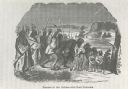
| Description: | Photograph of an engraving from an unknown source depicting a group of Native American warriors herding white captives along a trail. A building burns in ... |
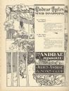
| Date: | 09 1895 |
|---|---|
| Description: | Full page, engraved advertisement for Andrae Cycles. Depicts men and women bicycling on a path in a bucolic setting, in addition to text promoting bicycles... |

| Date: | 1794 |
|---|---|
| Description: | Extremely detailed map of the south-eastern states, south from Virginia and east of the Mississippi River. It shows roads and paths, cities, towns, forts, ... |

| Date: | 1795 |
|---|---|
| Description: | Map of Maine, showing a few cities, harbors, hills, mountains, lakes, and rivers. A road runs from Pownalboro south to Portsmouth harbor, and the boundary ... |
If you didn't find the material you searched for, our Library Reference Staff can help.
Call our reference desk at 608-264-6535 or email us at: