 Filter: Categories of Wisconsin Historical Images
Filter: Subject of Engraving
Filter: Subject of rivers
Filter: Subject of plants
Filter: Categories of Wisconsin Historical Images
Filter: Subject of Engraving
Filter: Subject of rivers
Filter: Subject of plants

| Date: | 1821 |
|---|---|
| Description: | Engraving depicting the Schoolcraft expedition crossing the Ontonagon River to investigate a copper boulder. |

| Date: | 1832 |
|---|---|
| Description: | Junction of the Yellowstone River and the Missouri River. |
| Date: | 1832 |
|---|---|
| Description: | Herd of Bison, on the Upper Missouri River. |
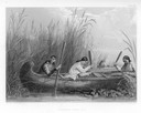
| Date: | 1884 |
|---|---|
| Description: | Three women in a canoe harvest wild rice. |
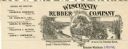
| Date: | |
|---|---|
| Description: | Letterhead of the Wisconsin Rubber Company of Madison, Wisconsin, which operated the Florida plantation in the state of Chiapas, Mexico. Includes an oval i... |
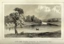
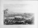
| Date: | 1856 |
|---|---|
| Description: | Lithographic view of Four Legs Village at the outlet of Lake Winnebago. There are is a person in a canoe on the river and a large tree in the foreground. S... |
| Date: | 1856 |
|---|---|
| Description: | Lithographic view of the Grande Chute Falls on the Fox River. There is a tent on the shore on the right. |
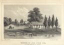
| Date: | 1856 |
|---|---|
| Description: | Lithograhic view of the residence of John Kinzie on the bank of the Chicago River at the mouth of Lake Michigan. The residence consists of a house with a f... |

| Date: | 1790 |
|---|---|
| Description: | An updated and corrected version of Robert de Vaugondy's 1750 map "Amérique Septentrionale: Dressée sur les Relations les Plus Modernes des Voyageurs et Na... |

| Date: | 1780 |
|---|---|
| Description: | This map shows the townships, parishes, cities, towns, plantations, lakes, rivers, swamps, and roads near the coast of South Carolina and Georgia. Emphasis... |

| Date: | 1776 |
|---|---|
| Description: | Map of Virginia and parts of Maryland and Delaware (written "De La War"). It shows borders, counties, cities, towns, plantations (marked by landowners name... |
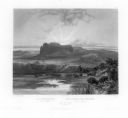
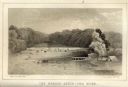
| Date: | 1884 |
|---|---|
| Description: | Lithographic engraving depicting two people on a bluff overlooking a river. Several canoes are present on the river. Caption reads: "'Valley of the Minneso... |
If you didn't find the material you searched for, our Library Reference Staff can help.
Call our reference desk at 608-264-6535 or email us at: