 Filter: Categories of Wisconsin Historical Images
Filter: Subject of Engraving
Filter: Subject of political science
Filter: Subject of trees
Filter: Categories of Wisconsin Historical Images
Filter: Subject of Engraving
Filter: Subject of political science
Filter: Subject of trees
| Date: | |
|---|---|
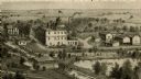
| Description: | An engraving based on a drawing by Alexander Simplot of the Platteville Brewery (spelled Plattville). It is an elevated perspective showing the main buildi... |
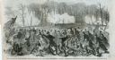
| Date: | 10 24 1863 |
|---|---|
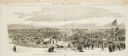
| Description: | Panoramic wood-engraving of a cattle fair in New Haven, after a sketch by H.C. Curtis. Caption reads: "Cattle Show and Agricultural Faib [sic] at Ha... |
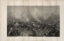
| Date: | |
|---|---|
| Description: | Steel engraving of the first major battle of the Civil War, fought in Virginia, near the Manassas, Virginia, railway junction, after which the battle is ca... |

| Date: | 1870 |
|---|---|
| Description: | Magazine illustration of the home, titled: "Soldiers' National Asylum at Milwaukee, Wisconsin". The building is in the background, and in the foreground ar... |
| Date: | 07 21 1861 |
|---|---|
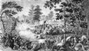
| Description: | Depiction of the battlefield. Engraved by J.C. McRae and drawn by W. Momberger. |
| Date: | 1863 |
|---|---|
| Description: | An engraving of the Battle of Gettysburg, after the painting by P.F. Rothermel. |
| Date: | 03 15 1862 |
|---|---|
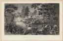
| Description: | Engraved Illustration for the story titled: "The Fight at Fort Donelson". The illustration shows the Second Iowa Volunteers regiment attacking Confederate ... |
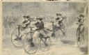
| Date: | 12 1868 |
|---|---|
| Description: | Engraved view of four women racing on bicycles. Spectators in the background are behind a fence. |

| Date: | |
|---|---|
| Description: | A scene including the American Fur Company buildings, an American flag, a lake and people in boats. |

| Date: | 1715 |
|---|---|
| Description: | One of Herman Moll's most famous maps, often referred to as The Codfish Map, it shows rivers and portages, cities, Indian villages, wind directions, routes... |

| Date: | 1758 |
|---|---|
| Description: | This map of the north-west hemisphere shows the cities, lakes, rivers, mountains, and political borders. In the upper left corner sits a decorative cartouc... |

| Date: | 1755 |
|---|---|
| Description: | This map shows the eastern half of North America during the French and Indian war, including cities, borders, Native American Land, forts, and detailed geo... |

| Date: | 1783 |
|---|---|
| Description: | This map is hand-colored and shows the boundaries of British, Spanish, and the newly recognized American claims, as well as the fishing rights granted to F... |

| Date: | 1747 |
|---|---|
| Description: | Map of America showing rivers, lakes, mountains, and regions, but primarily focusing on the French and Native American settlements along the Mississippi th... |

| Date: | 1758 |
|---|---|
| Description: | Map showing lakes, rivers, cities, Native American land, and the boundaries of French and English claims in America and Canada north of New York. A title c... |

| Date: | 1755 |
|---|---|
| Description: | Map of North America east of the Mississippi River showing cities, settlements, Native American land, mountains, lakes, rivers, and the boundaries between ... |

| Date: | 1778 |
|---|---|
| Description: | Map of European claims in North America, with France shown as having claim to the most land, and the British colonies confined to east of the Appalacian Mo... |

| Date: | 1770 |
|---|---|
| Description: | Map of North America showing the boundaries between French, Spanish, and English claims after the French and Indian War. Kitchin includes numerous place na... |

| Date: | 1760 |
|---|---|
| Description: | Map showing the towns, mountains, valleys, corn fields, and rivers of a portion of the Cherokee Nation. A few annotations on the map explain the land and r... |
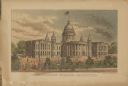
| Date: | |
|---|---|
| Description: | Elevated view of the Wisconsin State Capitol. Pedestrians are strolling along the grounds near a fountain. |
If you didn't find the material you searched for, our Library Reference Staff can help.
Call our reference desk at 608-264-6535 or email us at: