 Filter: Categories of Wisconsin Historical Images
Filter: Subject of Engraving
Filter: Subject of political science
Filter: Subject of land use
Filter: Categories of Wisconsin Historical Images
Filter: Subject of Engraving
Filter: Subject of political science
Filter: Subject of land use
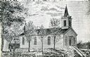
| Date: | 1854 |
|---|---|
| Description: | Exterior view of a First Congregational Church. |

| Date: | 1885 |
|---|---|
| Description: | Elevated view of the Park Hotel, with city traffic in the streets in the foreground. "'Park Hotel' South Corner Capitol Park." The reverse side gives a des... |
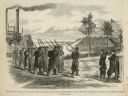
| Date: | 02 28 1863 |
|---|---|
| Description: | The First Regiment of the Louisiana Native Guards disembarking at Fort Macomb, Louisiana. The fort is adjacent to the Venetian Isles community, now legally... |
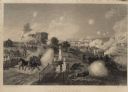
| Date: | |
|---|---|
| Description: | Engraving excerpted from John S.C. Abbott's History of the Civil War in America. |
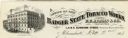
| Date: | |
|---|---|
| Description: | Letterhead of the Badger State Tobacco Works of Milwaukee, Wisconsin, with a three-quarter view of the building, men working on boats moored near the water... |
| Date: | |
|---|---|
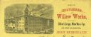
| Description: | Letterhead of the Milwaukee Willow Works, a manufacturer of children's carriages, willow ware, and toys, with a three-quarter view of the company building,... |
| Date: | 1875 |
|---|---|
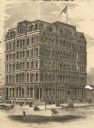
| Description: | Newspaper engraving of the building at Randolph and Dearborn Streets that served as the McCormick General Office from 1879 to 1885. An American flag flies ... |
| Date: | 12 1868 |
|---|---|
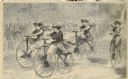
| Description: | Engraved view of four women racing on bicycles. Spectators in the background are behind a fence. |

| Date: | |
|---|---|
| Description: | A scene including the American Fur Company buildings, an American flag, a lake and people in boats. |

| Date: | 1715 |
|---|---|
| Description: | A map of the countries and islands surrounding the Gulf of Mexico. The hand-colored borders separate the territories of England, France, Spain, and Holland... |

| Date: | 1782 |
|---|---|
| Description: | Map of the West Indies and south eastern North America, remarkably detailed, showing cities, mountains, rivers, lakes, mines, plantations, forts, banks, an... |

| Date: | 1758 |
|---|---|
| Description: | This detailed map of north eastern America shows the boundaries, cities, mountains, rivers, lakes, Native American land and towns, and roads from east of t... |

| Date: | 1760 |
|---|---|
| Description: | Map showing the towns, mountains, valleys, corn fields, and rivers of a portion of the Cherokee Nation. A few annotations on the map explain the land and r... |
| Date: | |
|---|---|
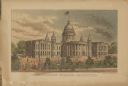
| Description: | Elevated view of the Wisconsin State Capitol. Pedestrians are strolling along the grounds near a fountain. |
If you didn't find the material you searched for, our Library Reference Staff can help.
Call our reference desk at 608-264-6535 or email us at: