 Filter: Categories of Wisconsin Historical Images
Filter: Subject of Engraving
Filter: Subject of mountains
Filter: Subject of dwellings
Filter: Categories of Wisconsin Historical Images
Filter: Subject of Engraving
Filter: Subject of mountains
Filter: Subject of dwellings
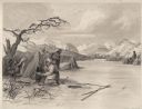
| Date: | 1884 |
|---|---|
| Description: | Small group of Native Americans spearing fish through ice on a river. Mountains can be seen in the background. |

| Date: | 1718 |
|---|---|
| Description: | Map of the Southern portion of North America from New Mexico to Florida and south from Lake Erie. It shows borders, cities, settlements, Native American la... |

| Date: | 1667 |
|---|---|
| Description: | Map of Virginia depicting the discoveries detailed by John Smith in his exploration of the region. It shows Jamestown, Native American tribes and villages,... |

| Date: | 1776 |
|---|---|
| Description: | Map of Virginia and parts of Maryland and Delaware (written "De La War"). It shows borders, counties, cities, towns, plantations (marked by landowners name... |
If you didn't find the material you searched for, our Library Reference Staff can help.
Call our reference desk at 608-264-6535 or email us at: