 Filter: Categories of Wisconsin Historical Images
Filter: Subject of Engraving
Filter: Subject of lakes
Filter: Subject of hats
Filter: Categories of Wisconsin Historical Images
Filter: Subject of Engraving
Filter: Subject of lakes
Filter: Subject of hats
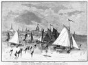
| Date: | 03 09 1878 |
|---|---|
| Description: | Illustration by N.A. Greenback of ice-skaters and iceboats featuring the new Poughkeepsie design of pivoting runners. A key at the bottom of the image iden... |
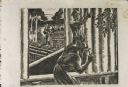
| Date: | 1937 |
|---|---|
| Description: | Linoleum cut engraved view of men building a log cabin. One man carries a log in the background near a lake or river, while another man nails a log held in... |
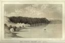
| Date: | 1856 |
|---|---|
| Description: | Lithographic view of a man in a canoe on Big-Foot's Lake (modern day Lake Geneva) with a small settlement on a bluff overlooking the lake. A group of birds... |

| Date: | 1790 |
|---|---|
| Description: | An updated and corrected version of Robert de Vaugondy's 1750 map "Amérique Septentrionale: Dressée sur les Relations les Plus Modernes des Voyageurs et Na... |

| Date: | 1676 |
|---|---|
| Description: | Detailed map of North and South America. Cities, towns, forests, and mountains are shown pictorially. Duval labels regions, islands, cities, lakes, and Nat... |

| Date: | 1780 |
|---|---|
| Description: | Map of North and South America, showing the boundaries of colonial territories, cities, settlements, rivers, lakes, and Native American land. Particular em... |

| Date: | 1684 |
|---|---|
| Description: | Map of North America showing some colonies, cities, rivers, lakes, and Native American land. Ship routes spread across both oceans, including one decorated... |

| Date: | 1683 |
|---|---|
| Description: | Map of the north east coast of North America showing islands, regions, Native American land, bays, and a few European settlements. The Great Lakes appear i... |

| Date: | 1710 |
|---|---|
| Description: | Map of North America showing the European claims, Native American land and villages, rivers, lakes, cities, and notes on explorers, discoveries, and topogr... |

| Date: | 1719 |
|---|---|
| Description: | Map of North America showing land divisions between France, Spain, England, Sweden, Denmark and Holland. The map is detailed, labeling cities, forts, islan... |

| Date: | 1770 |
|---|---|
| Description: | Map of North America from the Great Lakes to the northern portion of South America. It shows cities, Native American land, mountains, swamps, lakes, rivers... |

| Date: | 1759 |
|---|---|
| Description: | Map of north eastern Canada and parts of New England, showing settlements, cities, portages, Native American land, mountains, lakes, and rivers. The unusua... |

| Date: | 1890 |
|---|---|
| Description: | Advertisement for The Steam Yacht "Mendota." At the top is an engraving of the steam yacht under way loaded with passengers, and below is text. Some of the... |

| Date: | 1784 |
|---|---|
| Description: | Detailed and ornate map of the newly formed United States. The borders of the southern states extend to the Mississippi River, though the states are only c... |
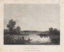
| Date: | 1858 |
|---|---|
| Description: | Engraved print of four men and a dog in a boat on Lake Winnebago. Two of the men are in the center of the boat holding hunting rifles, while one man is sta... |
If you didn't find the material you searched for, our Library Reference Staff can help.
Call our reference desk at 608-264-6535 or email us at: