 Filter: Categories of Wisconsin Historical Images
Filter: Subject of Engraving
Filter: Subject of intellectual life
Filter: Subject of hats
Filter: Categories of Wisconsin Historical Images
Filter: Subject of Engraving
Filter: Subject of intellectual life
Filter: Subject of hats
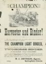
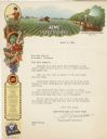
| Date: | 1882 |
|---|---|
| Description: | Advertising handbill for the Champion harvester and binder. Includes the text: "the Champion light binder, is the only simple, light, durable, efficient wo... |
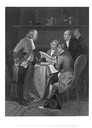
| Date: | |
|---|---|
| Description: | An engraving of Benjamin Franklin, Thomas Jefferson, John Adams, Philip Livingston, and Roger Sherman, drafters of the Declaration of Independence gathered... |
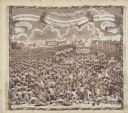
| Date: | 1819 |
|---|---|
| Description: | A commemorative handkerchief created by a wood engraving on white cotton fabric. The scene is the Manchester Reform Meeting, in England. A crowd of demonst... |
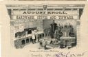
| Date: | 1888 |
|---|---|
| Description: | Letterhead of August Kroll of Leopolis, Wisconsin, dealer in hardware, stoves, and tinware, with an image of the interior of a store and customers being he... |
| Date: | |
|---|---|
| Description: | Letterhead of the Acme White Lead & Color Works of Detroit, Michigan, which as part of its business produced insecticides for farm and home garden applicat... |
| Date: | |
|---|---|
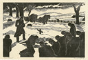
| Description: | Engraved view of a country burial in the snow. A clergyman reads a blessing as a mourner kneels near the grave. A group of mourners bow their heads. A team... |

| Date: | 1790 |
|---|---|
| Description: | An updated and corrected version of Robert de Vaugondy's 1750 map "Amérique Septentrionale: Dressée sur les Relations les Plus Modernes des Voyageurs et Na... |

| Date: | 1676 |
|---|---|
| Description: | Detailed map of North and South America. Cities, towns, forests, and mountains are shown pictorially. Duval labels regions, islands, cities, lakes, and Nat... |

| Date: | 1780 |
|---|---|
| Description: | Map of North and South America, showing the boundaries of colonial territories, cities, settlements, rivers, lakes, and Native American land. Particular em... |

| Date: | 1684 |
|---|---|
| Description: | Map of North America showing some colonies, cities, rivers, lakes, and Native American land. Ship routes spread across both oceans, including one decorated... |

| Date: | 1683 |
|---|---|
| Description: | Map of the north east coast of North America showing islands, regions, Native American land, bays, and a few European settlements. The Great Lakes appear i... |

| Date: | 1710 |
|---|---|
| Description: | Map of North America showing the European claims, Native American land and villages, rivers, lakes, cities, and notes on explorers, discoveries, and topogr... |

| Date: | 1719 |
|---|---|
| Description: | Map of North America showing land divisions between France, Spain, England, Sweden, Denmark and Holland. The map is detailed, labeling cities, forts, islan... |

| Date: | 1770 |
|---|---|
| Description: | Map of North America from the Great Lakes to the northern portion of South America. It shows cities, Native American land, mountains, swamps, lakes, rivers... |

| Date: | 1759 |
|---|---|
| Description: | Map of north eastern Canada and parts of New England, showing settlements, cities, portages, Native American land, mountains, lakes, and rivers. The unusua... |

| Date: | 1784 |
|---|---|
| Description: | Detailed and ornate map of the newly formed United States. The borders of the southern states extend to the Mississippi River, though the states are only c... |
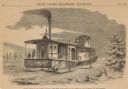
| Date: | 1859 |
|---|---|
| Description: | Engraved drawing of Norman Wiard's ice locomotive, the Lady Franklin operating on a frozen river. Male passengers and crew members are standing on t... |
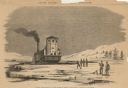
| Date: | 1859 |
|---|---|
| Description: | Engraved drawing of Norman Wiard's ice locomotive, Lady Franklin being pulled from water onto ice using its anchor. The vessel was built, but never ... |
If you didn't find the material you searched for, our Library Reference Staff can help.
Call our reference desk at 608-264-6535 or email us at: