 Filter: Categories of Wisconsin Historical Images
Filter: Subject of Engraving
Filter: Subject of intellectual life
Filter: Subject of botany
Filter: Categories of Wisconsin Historical Images
Filter: Subject of Engraving
Filter: Subject of intellectual life
Filter: Subject of botany

| Date: | 1821 |
|---|---|
| Description: | Engraving depicting the Schoolcraft expedition crossing the Ontonagon River to investigate a copper boulder. |

| Date: | 1906 |
|---|---|
| Description: | Bird's-eye map of South Milwaukee. |
| Date: | 1874 |
|---|---|
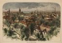
| Description: | Bird's-eye view of Milwaukee looking southwest toward the county courthouse under construction in the public square west of St. John's Cathedral. |

| Date: | 1857 |
|---|---|
| Description: | Bird's-eye view of Madison over rooftop and across lake with sailboats and steamers. A group of people are standing on a viewing platform on the roof in th... |

| Date: | 1937 |
|---|---|
| Description: | Bird's-eye view of Milwaukee in 1853 details building features and city layout from southwest. Important buildings are numbered in a silhouette drawing bel... |

| Date: | 1655 |
|---|---|
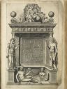
| Description: | Frontispiece to Newe Welt vnd americanische Historien (1655). |

| Date: | 1862 |
|---|---|
| Description: | Birds-eye view of a Wisconsin Civil War regiment on parade in Fond du Lac, as drawn by Louis Kurz from the Marr Street Methodist Church. The regiment canno... |
| Date: | 10 24 1863 |
|---|---|
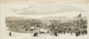
| Description: | Panoramic wood-engraving of a cattle fair in New Haven, after a sketch by H.C. Curtis. Caption reads: "Cattle Show and Agricultural Faib [sic] at Ha... |
| Date: | |
|---|---|
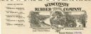
| Description: | Letterhead of the Wisconsin Rubber Company of Madison, Wisconsin, which operated the Florida plantation in the state of Chiapas, Mexico. Includes an oval i... |
| Date: | |
|---|---|
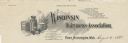
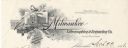
| Description: | Letterhead of the Wisconsin Dairymen's Association, based in Fort Atkinson, Wisconsin, with names of officers and members of the Executive Board and an ima... |
| Date: | |
|---|---|
| Description: | Letterhead of Plankinton House in Milwaukee, Wisconsin, with a three-quarter view of the hotel and traffic in the street, including people on foot, on hors... |
| Date: | |
|---|---|
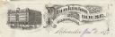
| Description: | Letterhead of the Milwaukee Lithographing & Engraving Company, with a three-quarter view of the building, set into a decorated border with the name of the ... |

| Date: | 1856 |
|---|---|
| Description: | Engravings of the Presidential and Vice-Presidential candidates from the Democratic, Republican and Know Nothing parties for the Tuesday, November 4th, 185... |
| Date: | 02 25 1926 |
|---|---|
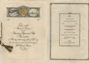
| Description: | Front cover and menu listing from the booklet printed for the Forty-ninth Annual Dinner of the American Paper and Pulp Association at the Waldorf Astoria H... |
| Date: | |
|---|---|
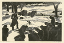
| Description: | Engraved view of a country burial in the snow. A clergyman reads a blessing as a mourner kneels near the grave. A group of mourners bow their heads. A team... |
| Date: | 1570 |
|---|---|
| Description: | Frontispiece for Abraham Ortelius' Theatrum Orbis Terrarum, published in 1570, and considered the first modern atlas. Title is surrounded by four figures r... |

| Date: | 1720 |
|---|---|
| Description: | Double hemispherical world map showing routes of Tasman, Magellan, Mendana, etc. Relief shown pictorially. Title in oak wreath cartouche. Map between four ... |

| Date: | 1746 |
|---|---|
| Description: | A map of the western hemisphere, including parts of western Europe and Africa, showing the division of the Americas by the European powers. Weapons and fol... |

| Date: | 1715 |
|---|---|
| Description: | One of Herman Moll's most famous maps, often referred to as The Codfish Map, it shows rivers and portages, cities, Indian villages, wind directions, routes... |

| Date: | 1758 |
|---|---|
| Description: | This map of the north-west hemisphere shows the cities, lakes, rivers, mountains, and political borders. In the upper left corner sits a decorative cartouc... |
If you didn't find the material you searched for, our Library Reference Staff can help.
Call our reference desk at 608-264-6535 or email us at: