 Filter: Categories of Wisconsin Historical Images
Filter: Subject of Engraving
Filter: Subject of industries
Filter: Subject of ships
Filter: Categories of Wisconsin Historical Images
Filter: Subject of Engraving
Filter: Subject of industries
Filter: Subject of ships

| Date: | 1847 |
|---|---|
| Description: | Engraving of the McCormick Reaper Works as it appeared in 1847. The factory was located on the north bank of the Chicago River, east of the Michigan Avenue... |
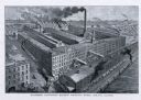
| Date: | 1885 |
|---|---|
| Description: | Engraved bird's-eye view illustration of the "McCormick Harvesting Machine Company's Works," including railroad cars, smoke from smokestacks and factory wo... |

| Date: | |
|---|---|
| Description: | Memohead of the Milwaukee Dry Dock Company, which operated two docks, with a view of a dock with ships, planks of wood, buildings, and the slogan, "Electri... |

| Date: | 1783 |
|---|---|
| Description: | This map is hand-colored and shows the boundaries of British, Spanish, and the newly recognized American claims, as well as the fishing rights granted to F... |

| Date: | 1755 |
|---|---|
| Description: | Map of Virginia and parts of Maryland, North Carolina, and New Jersey. It shows borders, boundary lines, some Native American land, counties, cities, towns... |

| Date: | 1781 |
|---|---|
| Description: | Map of the Southeastern part of the British Colonies in North America, Gulf Coast and Caribbean. It illustrates the of the Spanish and English fleets, part... |
If you didn't find the material you searched for, our Library Reference Staff can help.
Call our reference desk at 608-264-6535 or email us at: