 Filter: Categories of Wisconsin Historical Images
Filter: Subject of Engraving
Filter: Subject of indians of north america
Filter: Subject of canoes and canoeing
Filter: Categories of Wisconsin Historical Images
Filter: Subject of Engraving
Filter: Subject of indians of north america
Filter: Subject of canoes and canoeing
| Date: | 1832 |
|---|---|
| Description: | Punka Indians encamped on the banks of the Missouri River and canoeing in river. |
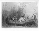
| Date: | 1884 |
|---|---|
| Description: | Three women in a canoe harvest wild rice. |
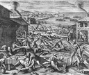
| Date: | 1655 |
|---|---|
| Description: | Scene from Jamestown Settlement, 1622, purporting to show the massacre of 347 settlers by Openchancanough and his alliance of tribes in the Jamestown area. |

| Date: | 1784 |
|---|---|
| Description: | Plate 50. Portrait from Cook's Third Expedition, 1776-1779, while in Alaska. |

| Date: | 1784 |
|---|---|
| Description: | Plate 57. Scene from Cook's Third Expedition, 1776-1779, while in Alaska. |
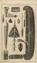
| Date: | 1821 |
|---|---|
| Description: | An illustration of items manufactured by Indians, including a canoe, two paddles, moccasins, rolled mat, pipe bowl, and a beaded bag. |
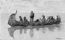
| Date: | 1892 |
|---|---|
| Description: | Photographic print of an engraved image showing a robed missionary standing in a birch bark canoe paddled by four Native Americans and another man who appe... |

| Date: | 1877 |
|---|---|
| Description: | Engraving of the Peck Cabin, after the painting by Mrs. E.E. Bailey. Caption at bottom reads: "First House in Madison. 1837." |

| Date: | 1783 |
|---|---|
| Description: | This map is hand-colored and shows the boundaries of British, Spanish, and the newly recognized American claims, as well as the fishing rights granted to F... |

| Date: | 1783 |
|---|---|
| Description: | Map of eastern Canada and part of America, with an inset map of the Great Lakes region in the lower left corner. It shows boundaries, cities, settlements, ... |

| Date: | 1718 |
|---|---|
| Description: | Map of the Southern portion of North America from New Mexico to Florida and south from Lake Erie. It shows borders, cities, settlements, Native American la... |
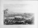
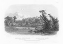
| Date: | 1884 |
|---|---|
| Description: | Lithographic engraving depicting two people on a bluff overlooking a river. Several canoes are present on the river. Caption reads: "'Valley of the Minneso... |
If you didn't find the material you searched for, our Library Reference Staff can help.
Call our reference desk at 608-264-6535 or email us at: