 Filter: Categories of Wisconsin Historical Images
Filter: Subject of Engraving
Filter: Subject of hills
Filter: Subject of agriculture
Filter: Categories of Wisconsin Historical Images
Filter: Subject of Engraving
Filter: Subject of hills
Filter: Subject of agriculture
| Date: | |
|---|---|
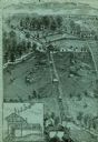
| Description: | An engraving based on a drawing by Alexander Simplot. The image shows a very detailed aerial view of a hillside with a tramway traversing the side. There a... |

| Date: | |
|---|---|
| Description: | Engraved print of a man riding atop a wagonload of hay pulled by a horse along a road in a hilly rural area. On the left is a barn and silos. |
| Date: | 1880 |
|---|---|
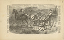
| Description: | Front page of booklet with an engraving of a man with a team of two horses in a field with the "Celebrated Gorham Sulky Cultivator." |

| Date: | 03 1777 |
|---|---|
| Description: | Map showing the British and Hessian attack on Fort Washington in November of 1776. The movements and fortifications of the British and Hessian troops appea... |

| Date: | 1760 |
|---|---|
| Description: | Map showing the towns, mountains, valleys, corn fields, and rivers of a portion of the Cherokee Nation. A few annotations on the map explain the land and r... |
If you didn't find the material you searched for, our Library Reference Staff can help.
Call our reference desk at 608-264-6535 or email us at: