Filter: Categories of Wisconsin Historical Images
Filter: Subject of Engraving
Filter: Subject of fortification
Filter: Categories of Wisconsin Historical Images
Filter: Subject of Engraving
Filter: Subject of fortification
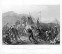
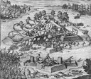
| Date: | 08 28 1833 |
|---|---|
| Description: | Indians fighting at Fort Mackenzie (Montana). |

| Date: | 1832 |
|---|---|
| Description: | Black and white engraving showing landscape with Fort Pierre and Indian tipis along the Missouri River. |
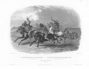
| Date: | 1832 |
|---|---|
| Description: | Horse racing of Sioux Indians near Fort Pierre. Three Sioux Indians on horseback in foreground and Fort Pierre in distance. |

| Date: | 1832 |
|---|---|
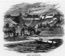
| Description: | Fort Union, on the Missouri River in Montana. |

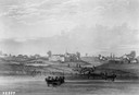
| Date: | 1832 |
|---|---|
| Description: | Fort Clark, on the Missouri River, February 1834. |
| Date: | 1655 |
|---|---|
| Description: | Engraving made after a painting by Jacques Le Moyne de Morgues (died 1588) during the Laudonnière Expedition in Florida, ca. 1564. |
| Date: | 1655 |
|---|---|
| Description: | Scene from Laudonnière Expedition in Florida, ca. 1567. |

| Date: | 1655 |
|---|---|
| Description: | Map from Drake Expedition in Florida, ca. 1585. |
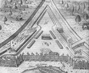
| Date: | 1820 |
|---|---|
| Description: | Engraving of Fort Dearborn (center) and Kinzie Mansion (right) after Seth Eastman's original drawing in 1820 for the U. S. Army. Several people are visible... |
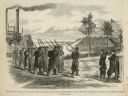
| Date: | 02 28 1863 |
|---|---|
| Description: | The First Regiment of the Louisiana Native Guards disembarking at Fort Macomb, Louisiana. The fort is adjacent to the Venetian Isles community, now legally... |
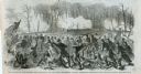
| Date: | 03 15 1862 |
|---|---|
| Description: | Engraved Illustration for the story titled: "The Fight at Fort Donelson". The illustration shows the Second Iowa Volunteers regiment attacking Confederate ... |

| Date: | 1719 |
|---|---|
| Description: | Map of the Great Lakes and the St. Lawrence river showing French and English cities and villages, trading posts, Indian villages and tribes, portages, for... |

| Date: | 1755 |
|---|---|
| Description: | Large format map of America and Canada east of the Mississippi River. D'Anville marks the locations of rivers, lakes, settlements, cities, Native American ... |

| Date: | 1780 |
|---|---|
| Description: | Map of North America from Lake Ontario through the Great Plains, and James Bay to Illinois. It shows rivers, lakes, and mountains in great detail, and labe... |

| Date: | 1780 |
|---|---|
| Description: | Map of North America east of Mexico showing colonial boundaries, forts, cities, Native American land, mountains, waterfalls, lakes, and rivers. Short notes... |

| Date: | 1770 |
|---|---|
| Description: | Map of North America showing the boundaries between French, Spanish, and English claims after the French and Indian War. Kitchin includes numerous place na... |

| Date: | 1755 |
|---|---|
| Description: | Map of New England, with three inset maps of Fort Oswego, Fort du Quesne, and Fort Frederick. It shows colonies, a few cities, forts (marked as French or E... |

| Date: | 1735 |
|---|---|
| Description: | Map of the Chesapeake Bay region and surrounding areas, with north oriented towards the right. A few forts, rivers, and bays are labeled, as are the region... |

| Date: | 1760 |
|---|---|
| Description: | Map showing upstate New York, Lake Ontario, and the St. Lawrence River during the last, decisive battle of the French and Indian War. The main map shows a ... |
If you didn't find the material you searched for, our Library Reference Staff can help.
Call our reference desk at 608-264-6535 or email us at: