Filter: Categories of Wisconsin Historical Images
Filter: Subject of Engraving
Filter: Subject of command of troops
Filter: Categories of Wisconsin Historical Images
Filter: Subject of Engraving
Filter: Subject of command of troops
| Date: | |
|---|---|
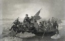
| Description: | Engraving of George Washington and his troops rowing across an icy Delaware River to attack the British, from the painting by E. Leutze. |
| Date: | |
|---|---|
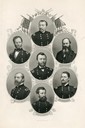
| Description: | Engraving of portraits of Civil War Union Army generals, clockwise from the top, P.H. Sheridan, D.D. Porter, W.S. Hancock, O.O. Howard, George G. Meade, W.... |
| Date: | 1655 |
|---|---|
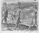
| Description: | Engraving made after a painting by Jacques Le Moyne de Morgues (died 1588) while on the Laudonnière Expedition in Florida, ca. 1564. |
| Date: | 1655 |
|---|---|
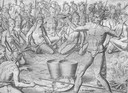
| Description: | Engraving made after a painting by Jacques Le Moyne de Morgues (died 1588) during the Laudonnière Expedition in Florida, ca. 1564. |
| Date: | |
|---|---|
| Description: | Portrait engraving of George Washington from a painting by J.G. Chapman after C.W. Peale. |
| Date: | |
|---|---|
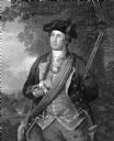
| Description: | Portrait engraving of George Washington in military regalia, from a painting by Colonel Trumbull. |
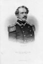
| Date: | |
|---|---|
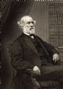
| Description: | Portrait engraving of Major General Robert E. Lee of the Confederate Army. |
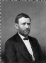
| Date: | |
|---|---|
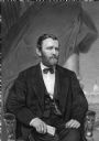
| Description: | Portrait engraving of Ulysses S. Grant, "From the photograph preferred by himself, 1869." |

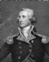
| Date: | |
|---|---|
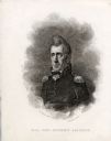
| Description: | Portrait of Brigadeer General Anthony Wayne, taken from an engraving from "The National Portrait Gallery of Distinguished Americans". |

| Date: | 1755 |
|---|---|
| Description: | Map of New England, with three inset maps of Fort Oswego, Fort du Quesne, and Fort Frederick. It shows colonies, a few cities, forts (marked as French or E... |

| Date: | 1760 |
|---|---|
| Description: | Map showing the towns, mountains, valleys, corn fields, and rivers of a portion of the Cherokee Nation. A few annotations on the map explain the land and r... |
If you didn't find the material you searched for, our Library Reference Staff can help.
Call our reference desk at 608-264-6535 or email us at: