 Filter: Categories of Wisconsin Historical Images
Filter: Subject of Engraving
Filter: Subject of clothing
Filter: Subject of hats
Filter: Categories of Wisconsin Historical Images
Filter: Subject of Engraving
Filter: Subject of clothing
Filter: Subject of hats
| Date: | 1892 |
|---|---|
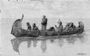
| Description: | Photographic print of an engraved image showing a robed missionary standing in a birch bark canoe paddled by four Native Americans and another man who appe... |

| Date: | 1770 |
|---|---|
| Description: | Map of North America from the Great Lakes to the northern portion of South America. It shows cities, Native American land, mountains, swamps, lakes, rivers... |

| Date: | 1667 |
|---|---|
| Description: | Map of Virginia depicting the discoveries detailed by John Smith in his exploration of the region. It shows Jamestown, Native American tribes and villages,... |
If you didn't find the material you searched for, our Library Reference Staff can help.
Call our reference desk at 608-264-6535 or email us at: