Filter: Categories of Wisconsin Historical Images
Filter: Subject of Engraving
Filter: Subject of cities and towns
Filter: Categories of Wisconsin Historical Images
Filter: Subject of Engraving
Filter: Subject of cities and towns
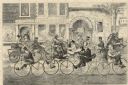
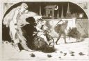
| Date: | 05 01 1869 |
|---|---|
| Description: | Humorous engraved image showing a street scene crowded with people riding bicycles. In the background are businesses identified as J. Shanks Livery Stable,... |
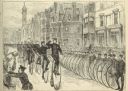
| Date: | 05 30 1881 |
|---|---|
| Description: | Engraving of a sketch by Joseph Pennell showing a parade of League of American Wheelmen bicyclists along Commonwealth Avenue between Dartmouth Street and W... |
| Date: | 01 1869 |
|---|---|
| Description: | Engraving after a drawing by Winslow Homer showing a crowned Baby New Year riding a velocipede through a hoop held by a woman, as the Grim Reaper, on the r... |

| Date: | 1831 |
|---|---|
| Description: | Map of the city of Louisville, Kentucky on the Ohio River showing streets and numbered lots. The Ohio River, Corn Island, and the Louisville and Portland C... |
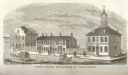
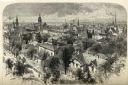
| Date: | 1815 |
|---|---|
| Description: | Engraved view of the first state buildings in Columbus, Ohio, including the United States Courthouse, Public Offices and the Old State House. A number of p... |
| Date: | 1810 |
|---|---|
| Description: | View of the city of Lincoln, England. Photocopy after an engraving by B.G. Topham. |

| Date: | 1712 |
|---|---|
| Description: | Engraved double-hemispherical world map by Moll, included in his atlas The world described, or, A new and correct sett of maps: shewing the kingdoms and st... |
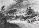
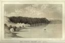
| Date: | 1856 |
|---|---|
| Description: | Lithographic view of Four Legs Village at the outlet of Lake Winnebago. There are is a person in a canoe on the river and a large tree in the foreground. S... |
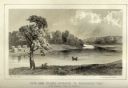
| Date: | 1856 |
|---|---|
| Description: | Lithographic view of a man in a canoe on Big-Foot's Lake (modern day Lake Geneva) with a small settlement on a bluff overlooking the lake. A group of birds... |

| Date: | |
|---|---|
| Description: | Letterhead of Johnson & Melaas, merchant tailors and cloth dealers, "Buyers of wool and Wisconsin leaf tobacco," with an engraving of a waterfront view of ... |

| Date: | 1877 |
|---|---|
| Description: | Engraving of the Peck Cabin, after the painting by Mrs. E.E. Bailey. Caption at bottom reads: "First House in Madison. 1837." |

| Date: | 1715 |
|---|---|
| Description: | A map of the countries and islands surrounding the Gulf of Mexico. The hand-colored borders separate the territories of England, France, Spain, and Holland... |

| Date: | 1721 |
|---|---|
| Description: | A map of North and South America with an elaborately illustrated cartouche depicting Native Americans in upper left corner. The map is fairly detailed, dep... |

| Date: | 1735 |
|---|---|
| Description: | A map of the western hemisphere, including parts of western Europe and Africa. Portraits of explorers, such as Jacques Marquette, Louis Joliet, and Robert ... |

| Date: | 1739 |
|---|---|
| Description: | This map shows the territorial claims of the western hemisphere by the European powers, as well as the names of major cities, geographical features, and pa... |

| Date: | 1761 |
|---|---|
| Description: | This map shows the western hemisphere. Much of the north-west coast of North America is left blank, but the rest of the map lists the names of rivers, citi... |
If you didn't find the material you searched for, our Library Reference Staff can help.
Call our reference desk at 608-264-6535 or email us at: