Filter: Categories of Wisconsin Historical Images
Filter: Subject of Engraving
Filter: Subject of cities and towns
Filter: Subject of rivers
Filter: Categories of Wisconsin Historical Images
Filter: Subject of Engraving
Filter: Subject of cities and towns
Filter: Subject of rivers

| Date: | 1871 |
|---|---|
| Description: | Drawing of the Peshtigo Fire, showing people seeking refuge in the Peshtigo River. |
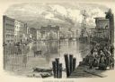
| Date: | 1867 |
|---|---|
| Description: | Engraving of the McCormick Reaper Works as it appeared in 1867. The factory was located on the north bank of the Chicago River, east of the Rush Street bri... |

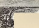
| Date: | 1937 |
|---|---|
| Description: | Bird's-eye view of Milwaukee in 1853 details building features and city layout from southwest. Important buildings are numbered in a silhouette drawing bel... |
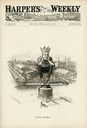
| Date: | 07 14 1894 |
|---|---|
| Description: | Cartoon depicting "King Debs" a man wearing a crown representing Debs American Railway Union, sitting atop the highway of trade. |
| Date: | |
|---|---|
| Description: | Lithographed drawing of the mouth of the St. Croix River depicting a sailing barge and steamboat in the distance. Print is part of a series collected in Le... |

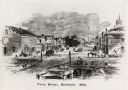
| Date: | 1890 |
|---|---|
| Description: | Exterior of building, with arched main entrance. The road in front is crowded with pedestrians, trolleys, and horse-drawn vehicles. On the left is a boat ... |

| Date: | 1856 |
|---|---|
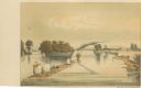
| Description: | View along bridge of paddle boats and ships in the harbor, pedestrians, and the town in the background on the other side of the river. |
| Date: | 1856 |
|---|---|
| Description: | View from bridge on river. Storefronts and homes line the road that stretches to the horizon. |

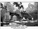
| Date: | 1930 |
|---|---|
| Description: | Color illustration of the Rush Street Bridge and Chicago River as it appeared in 1861. Includes the C.H. McCormick Reaper Works on the far side of the rive... |
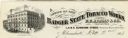
| Date: | |
|---|---|
| Description: | Letterhead of the Badger State Tobacco Works of Milwaukee, Wisconsin, with a three-quarter view of the building, men working on boats moored near the water... |
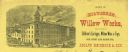
| Date: | |
|---|---|
| Description: | Letterhead of the Milwaukee Willow Works, a manufacturer of children's carriages, willow ware, and toys, with a three-quarter view of the company building,... |

| Date: | |
|---|---|
| Description: | Memohead of the Milwaukee Dry Dock Company, which operated two docks, with a view of a dock with ships, planks of wood, buildings, and the slogan, "Electri... |

| Date: | 1831 |
|---|---|
| Description: | Map of the city of Louisville, Kentucky on the Ohio River showing streets and numbered lots. The Ohio River, Corn Island, and the Louisville and Portland C... |

| Date: | 1712 |
|---|---|
| Description: | Engraved double-hemispherical world map by Moll, included in his atlas The world described, or, A new and correct sett of maps: shewing the kingdoms and st... |
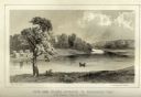
| Date: | 1856 |
|---|---|
| Description: | Lithographic view of Four Legs Village at the outlet of Lake Winnebago. There are is a person in a canoe on the river and a large tree in the foreground. S... |

| Date: | 1721 |
|---|---|
| Description: | A map of North and South America with an elaborately illustrated cartouche depicting Native Americans in upper left corner. The map is fairly detailed, dep... |

| Date: | 1761 |
|---|---|
| Description: | This map shows the western hemisphere. Much of the north-west coast of North America is left blank, but the rest of the map lists the names of rivers, citi... |
If you didn't find the material you searched for, our Library Reference Staff can help.
Call our reference desk at 608-264-6535 or email us at: