 Filter: Categories of Wisconsin Historical Images
Filter: Subject of Engraving
Filter: Subject of cities and towns
Filter: Subject of canoes and canoeing
Filter: Categories of Wisconsin Historical Images
Filter: Subject of Engraving
Filter: Subject of cities and towns
Filter: Subject of canoes and canoeing
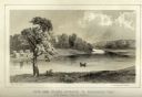
| Date: | 1856 |
|---|---|
| Description: | Lithographic view of Four Legs Village at the outlet of Lake Winnebago. There are is a person in a canoe on the river and a large tree in the foreground. S... |
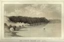
| Date: | 1856 |
|---|---|
| Description: | Lithographic view of a man in a canoe on Big-Foot's Lake (modern day Lake Geneva) with a small settlement on a bluff overlooking the lake. A group of birds... |

| Date: | 1877 |
|---|---|
| Description: | Engraving of the Peck Cabin, after the painting by Mrs. E.E. Bailey. Caption at bottom reads: "First House in Madison. 1837." |

| Date: | 1783 |
|---|---|
| Description: | This map is hand-colored and shows the boundaries of British, Spanish, and the newly recognized American claims, as well as the fishing rights granted to F... |

| Date: | 1783 |
|---|---|
| Description: | Map of eastern Canada and part of America, with an inset map of the Great Lakes region in the lower left corner. It shows boundaries, cities, settlements, ... |

| Date: | 1718 |
|---|---|
| Description: | Map of the Southern portion of North America from New Mexico to Florida and south from Lake Erie. It shows borders, cities, settlements, Native American la... |
If you didn't find the material you searched for, our Library Reference Staff can help.
Call our reference desk at 608-264-6535 or email us at: