 Filter: Categories of Wisconsin Historical Images
Filter: Subject of Engraving
Filter: Subject of botany
Filter: Subject of fortification
Filter: Categories of Wisconsin Historical Images
Filter: Subject of Engraving
Filter: Subject of botany
Filter: Subject of fortification
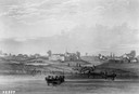
| Date: | 1820 |
|---|---|
| Description: | Engraving of Fort Dearborn (center) and Kinzie Mansion (right) after Seth Eastman's original drawing in 1820 for the U. S. Army. Several people are visible... |
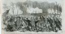
| Date: | 03 15 1862 |
|---|---|
| Description: | Engraved Illustration for the story titled: "The Fight at Fort Donelson". The illustration shows the Second Iowa Volunteers regiment attacking Confederate ... |

| Date: | 1770 |
|---|---|
| Description: | Map of North America showing the boundaries between French, Spanish, and English claims after the French and Indian War. Kitchin includes numerous place na... |

| Date: | 1755 |
|---|---|
| Description: | Map of New England, with three inset maps of Fort Oswego, Fort du Quesne, and Fort Frederick. It shows colonies, a few cities, forts (marked as French or E... |

| Date: | 03 1777 |
|---|---|
| Description: | Map showing the British and Hessian attack on Fort Washington in November of 1776. The movements and fortifications of the British and Hessian troops appea... |
If you didn't find the material you searched for, our Library Reference Staff can help.
Call our reference desk at 608-264-6535 or email us at: