 Filter: Categories of Wisconsin Historical Images
Filter: Subject of Engraving
Filter: Subject of animals
Filter: Subject of ships
Filter: Categories of Wisconsin Historical Images
Filter: Subject of Engraving
Filter: Subject of animals
Filter: Subject of ships
| Date: | 1655 |
|---|---|
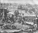
| Description: | Scene from near Jamestown Settlement in Virginia, ca. 1614. The Chickahominy tribe's proximity to Jamestown meant they had early contact with the English.... |

| Date: | 1890 |
|---|---|
| Description: | Exterior of building, with arched main entrance. The road in front is crowded with pedestrians, trolleys, and horse-drawn vehicles. On the left is a boat ... |

| Date: | 1885 |
|---|---|
| Description: | Engraved bird's-eye view illustration of the "McCormick Harvesting Machine Company's Works," including railroad cars, smoke from smokestacks and factory wo... |
| Date: | |
|---|---|
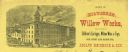
| Description: | Letterhead of the Milwaukee Willow Works, a manufacturer of children's carriages, willow ware, and toys, with a three-quarter view of the company building,... |

| Date: | 1783 |
|---|---|
| Description: | This map is hand-colored and shows the boundaries of British, Spanish, and the newly recognized American claims, as well as the fishing rights granted to F... |

| Date: | 1556 |
|---|---|
| Description: | One of the earliest obtainable maps to accurately (for its time) depict the Americas, this map shows more decorative than descriptive features. A few river... |

| Date: | 1636 |
|---|---|
| Description: | Map of North America, divided into regions, and showing some rivers, lakes, settlements, cities, mountains, and Native American land. Of the Great Lakes on... |

| Date: | 1713 |
|---|---|
| Description: | Map showing the regions explored by Robert de La Salle between 1681 and 1686, as well as the route La Salle, and later Henri Joutel, took, moving north fro... |

| Date: | 1733 |
|---|---|
| Description: | This map of North America shows settlements, rivers, lakes, Native American land, trade winds, and numerous topographical features such as forests and moun... |

| Date: | 1758 |
|---|---|
| Description: | Map showing lakes, rivers, cities, Native American land, and the boundaries of French and English claims in America and Canada north of New York. A title c... |

| Date: | 1759 |
|---|---|
| Description: | Map of north eastern Canada and parts of New England, showing settlements, cities, portages, Native American land, mountains, lakes, and rivers. The unusua... |

| Date: | 1718 |
|---|---|
| Description: | Map of the Southern portion of North America from New Mexico to Florida and south from Lake Erie. It shows borders, cities, settlements, Native American la... |
If you didn't find the material you searched for, our Library Reference Staff can help.
Call our reference desk at 608-264-6535 or email us at: