 Filter: Categories of Wisconsin Historical Images
Filter: Subject of Dwellings
Filter: Year of 1700-1799
Filter: Subject of indians of north america
Filter: Categories of Wisconsin Historical Images
Filter: Subject of Dwellings
Filter: Year of 1700-1799
Filter: Subject of indians of north america

| Date: | 1784 |
|---|---|
| Description: | Plate 41. Scene from Cook's Third Expedition, 1776-1779, while in Alaska. |

| Date: | 1784 |
|---|---|
| Description: | Plate 42. Scene from Cook's Third Expedition, 1776-1779, while in Alaska. |

| Date: | 1784 |
|---|---|
| Description: | Plate 57. Scene from Cook's Third Expedition, 1776-1779, while in Alaska. |

| Date: | 1784 |
|---|---|
| Description: | Plate 58. Scene from Cook's Third Expedition, 1776-1779, while in Alaska. |
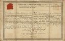
| Date: | 08 17 1778 |
|---|---|
| Description: | Document supporting the presentation of a medal presented by Frederick Haldimand, Captain-General and Governor in Chief of the Province of Quebec to Menomi... |

| Date: | 1720 |
|---|---|
| Description: | This map of North America shows cities, rivers, lakes, and a few topographical features, complete with numerous descriptive blocks of text about expedition... |

| Date: | 1783 |
|---|---|
| Description: | Map of eastern Canada and part of America, with an inset map of the Great Lakes region in the lower left corner. It shows boundaries, cities, settlements, ... |

| Date: | 1776 |
|---|---|
| Description: | Map showing New England, Nova Scotia, and Newfoundland, based on the seminal work of D' Anville, as well as the works of Belllin and de Vaugondy. It shows ... |

| Date: | 1718 |
|---|---|
| Description: | Map of the Southern portion of North America from New Mexico to Florida and south from Lake Erie. It shows borders, cities, settlements, Native American la... |
If you didn't find the material you searched for, our Library Reference Staff can help.
Call our reference desk at 608-264-6535 or email us at: