 Filter: Categories of Wisconsin Historical Images
Filter: Subject of Clothing and dress
Filter: Year of 1600-1699
Filter: Categories of Wisconsin Historical Images
Filter: Subject of Clothing and dress
Filter: Year of 1600-1699

| Date: | 1683 |
|---|---|
| Description: | Map of the north east coast of North America showing islands, regions, Native American land, bays, and a few European settlements. The Great Lakes appear i... |

| Date: | 1673 |
|---|---|
| Description: | Decorative map of the southeastern region of North America, from the York River in Virginia to northern Florida. The coat of arms of France and England mar... |

| Date: | 1667 |
|---|---|
| Description: | Map of Virginia depicting the discoveries detailed by John Smith in his exploration of the region. It shows Jamestown, Native American tribes and villages,... |

| Date: | 1671 |
|---|---|
| Description: | Map of Virginia depicting the discoveries detailed by John Smith in his exploration of the region. It shows Jamestown, Native American tribes and villages,... |

| Date: | 1609 |
|---|---|
| Description: | Illustration of an elevated view of a battle between Iroquois tribe and French on the banks of river. The Iroquois are unclothed and armed with bows and ar... |
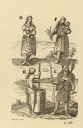
| Date: | 1615 |
|---|---|
| Description: | Drawings of four Native Americans. A and C are dressed for combat. B appears to be a woman carrying and nursing an infant, and D is wearing winter garb, in... |
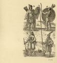
| Date: | 1616 |
|---|---|
| Description: | Illustration of four Algonquian Indians. E depicts a man dressed for combat in wood armor. F shows a woman in her regular dress carrying a child and an ear... |
If you didn't find the material you searched for, our Library Reference Staff can help.
Call our reference desk at 608-264-6535 or email us at: