 Filter: Categories of Wisconsin Historical Images
Filter: Subject of Clothing and dress
Filter: Subject of rivers
Filter: Subject of marshes
Filter: Categories of Wisconsin Historical Images
Filter: Subject of Clothing and dress
Filter: Subject of rivers
Filter: Subject of marshes
| Date: | 1900 |
|---|---|
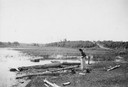
| Description: | A woman stands in a marsh near the site of Eleazer William's first house. |
| Date: | 1895 |
|---|---|
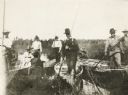
| Description: | Group of men, with women passengers, poling canoes through a marshy stretch of water on the Brule River-St. Croix River portage between Lake Superior and t... |

| Date: | |
|---|---|
| Description: | View across a marshy area towards a man, Mike Heberlein (of Cambridge), fishing while sitting in a wooden, ladder-back, dining chair that is submerged in t... |
| Date: | |
|---|---|
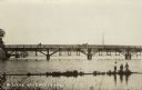
| Description: | View from shore towards a bridge crossing a river. Three boys are standing in the marshy foreground, and one of them has a fishing pole. A horse and buggy ... |

| Date: | 1770 |
|---|---|
| Description: | Map of North America from the Great Lakes to the northern portion of South America. It shows cities, Native American land, mountains, swamps, lakes, rivers... |

| Date: | 1740 |
|---|---|
| Description: | Map including the regions and cities of the northern half of North America. Native American land, rivers, lakes, mountains are labeled. Mountains, marshes,... |

| Date: | 1784 |
|---|---|
| Description: | Detailed and ornate map of the newly formed United States. The borders of the southern states extend to the Mississippi River, though the states are only c... |

| Date: | 1755 |
|---|---|
| Description: | Map of Virginia and parts of Maryland, North Carolina, and New Jersey. It shows borders, boundary lines, some Native American land, counties, cities, towns... |

| Date: | |
|---|---|
| Description: | View down hill where grassy fields lead down to the Yahara River where it meets Lake Waubesa. Two children are walking through the grass on the left. Capti... |

| Date: | 10 04 1906 |
|---|---|
| Description: | A man is sitting on a rock by a river's edge under trees. Vicinity of Chicago. |

| Date: | 1905 |
|---|---|
| Description: | View from shoreline looking towards two women wearing large hats who are sitting in a carriage drawn by a matched team of horses. The carriage has stopped ... |
If you didn't find the material you searched for, our Library Reference Staff can help.
Call our reference desk at 608-264-6535 or email us at: