 Filter: Categories of Wisconsin Historical Images
Filter: Subject of Clothing and dress
Filter: Subject of mississippi river
Filter: Subject of rivers
Filter: Categories of Wisconsin Historical Images
Filter: Subject of Clothing and dress
Filter: Subject of mississippi river
Filter: Subject of rivers

| Date: | 1975 |
|---|---|
| Description: | Woman in a boat showing a fish she has just caught on the Mississippi River. |

| Date: | 1870 |
|---|---|
| Description: | Half stereograph of an elevated view from hill showing the confluence of the Mississippi River and the St. Croix River. A man wearing a hat is in the foreg... |
| Date: | 1890 |
|---|---|
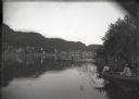
| Description: | Oblique view from the Mississippi River. Two young women are in a rowboat near the shoreline, and two young men are fishing in the river. Alma at the foot ... |
| Date: | 1897 |
|---|---|
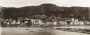
| Description: | View of Alma from the Mississippi River, with wing dam on right. |

| Date: | 1900 |
|---|---|
| Description: | Boys undressing to go swimming in the Mississippi River. Alma, Wisconsin is across the river in the background. |

| Date: | |
|---|---|
| Description: | Man standing on bluff with Mississippi River far below in the background. |

| Date: | 1713 |
|---|---|
| Description: | Map showing the regions explored by Robert de La Salle between 1681 and 1686, as well as the route La Salle, and later Henri Joutel, took, moving north fro... |

| Date: | 1740 |
|---|---|
| Description: | Map including the regions and cities of the northern half of North America. Native American land, rivers, lakes, mountains are labeled. Mountains, marshes,... |

| Date: | 1784 |
|---|---|
| Description: | Detailed and ornate map of the newly formed United States. The borders of the southern states extend to the Mississippi River, though the states are only c... |

| Date: | 1720 |
|---|---|
| Description: | Detailed, ornate, and comprehensive map of America from the east coast to present day Texas. Numerous features appear throughout the map, including Native ... |

| Date: | 08 01 2015 |
|---|---|
| Description: | Group portrait of three men and a woman, all wearing sunglasses. The two younger men are wearing baseball hats, and the woman is wearing a blue scarf. Behi... |
| Date: | 1961 |
|---|---|
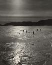
| Description: | People ice fishing on the frozen Mississippi River. Hills can be seen on the shoreline in the background. |
If you didn't find the material you searched for, our Library Reference Staff can help.
Call our reference desk at 608-264-6535 or email us at: