 Filter: Categories of Wisconsin Historical Images
Filter: Subject of Clothing and dress
Filter: Subject of land
Filter: Subject of bays
Filter: Categories of Wisconsin Historical Images
Filter: Subject of Clothing and dress
Filter: Subject of land
Filter: Subject of bays

| Date: | 1954 |
|---|---|
| Description: | View looking west from Eagle Bluff toward Nicolet Bay, the Strawberry Islands, and Chambers Island. Three people are sitting on the stone wall of the overl... |

| Date: | 1683 |
|---|---|
| Description: | Map of the north east coast of North America showing islands, regions, Native American land, bays, and a few European settlements. The Great Lakes appear i... |

| Date: | 1667 |
|---|---|
| Description: | Map of Virginia depicting the discoveries detailed by John Smith in his exploration of the region. It shows Jamestown, Native American tribes and villages,... |

| Date: | 1671 |
|---|---|
| Description: | Map of Virginia depicting the discoveries detailed by John Smith in his exploration of the region. It shows Jamestown, Native American tribes and villages,... |

| Date: | 1755 |
|---|---|
| Description: | Map of Virginia and parts of Maryland, North Carolina, and New Jersey. It shows borders, boundary lines, some Native American land, counties, cities, towns... |
| Date: | |
|---|---|
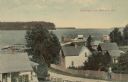
| Description: | Elevated view from hill of the bay and Ephraim. A man is walking up the hill on a road with buildings and fences on both sides. Caption reads: "Greetings f... |
| Date: | 1907 |
|---|---|
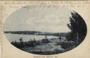
| Description: | Oval framed view of Ephraim from across the bay. A man is standing in the foreground. Caption reads: "Greetings from Ephraim, Wis." |
| Date: | 1967 |
|---|---|
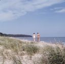
| Description: | View across grass and sand towards a young couple, a man and woman, holding hands and walking along the shoreline of Whitefish Bay. Trees are along the cur... |
| Date: | |
|---|---|
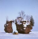
| Description: | View across frozen bay towards a person riding a snowmobile in front of a split rock formation on Chequamegon Bay. |

| Date: | |
|---|---|
| Description: | A man and women are posing on a rock formation and looking out over the big bay near Stand Rock. Boats are on the river in the distance. |

| Date: | |
|---|---|
| Description: | An unidentified young man is standing next to an unidentified young women sitting on a rock over looking Palisades and Big Bay. |
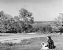
| Date: | 06 1938 |
|---|---|
| Description: | View looking down towards a woman wearing a plaid jacket sitting on the ground with her hand on a dog lying beside her in Peninsula State Park. There is a ... |

| Date: | 03 1913 |
|---|---|
| Description: | George F. Brumder and his wife, Thekla Wollaeger Brumder, center, are joined by an unidentified woman sitting on a stone wall. All of them are wearing hats... |

| Date: | 1939 |
|---|---|
| Description: | Advertising proof. Features an illustration of a man driving a truck in the Court of Pacifica. Below is Treasure Island and the hills of Berkeley. |
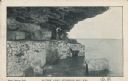
| Date: | 01 17 1907 |
|---|---|
| Description: | Text on front reads: "Lovers' Leap, Sturgeon Bay, Wis." Two men are posing while sitting on a block of stone under an overhang on Cabot's Point. The shorel... |
If you didn't find the material you searched for, our Library Reference Staff can help.
Call our reference desk at 608-264-6535 or email us at: