 Filter: Categories of Wisconsin Historical Images
Filter: Subject of Clothing and dress
Filter: Subject of intellectual life
Filter: Subject of mississippi river
Filter: Categories of Wisconsin Historical Images
Filter: Subject of Clothing and dress
Filter: Subject of intellectual life
Filter: Subject of mississippi river
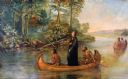
| Date: | 1921 |
|---|---|
| Description: | Painted scene of an Indian guide paddling, Jacques Marquette, a Jesuit missionary standing, and Louis Joliet, a fur trader paddling in a canoe exploring th... |

| Date: | |
|---|---|
| Description: | A painting depicting Marquette and Joliet in a birch bark canoe with two other men during their excursion on the Mississippi River, which they discovered o... |

| Date: | |
|---|---|
| Description: | Letterhead of the John Gund Brewing Company of La Crosse, Wisconsin, with an elevated view of the brewery complex on the left. On the right is the company ... |

| Date: | |
|---|---|
| Description: | Composite of sixteen views mainly views of types of boats on the Mississippi River, including steamboats and excursion boats; one view is a bird-eye view o... |

| Date: | 1713 |
|---|---|
| Description: | Map showing the regions explored by Robert de La Salle between 1681 and 1686, as well as the route La Salle, and later Henri Joutel, took, moving north fro... |

| Date: | 1740 |
|---|---|
| Description: | Map including the regions and cities of the northern half of North America. Native American land, rivers, lakes, mountains are labeled. Mountains, marshes,... |

| Date: | 1784 |
|---|---|
| Description: | Detailed and ornate map of the newly formed United States. The borders of the southern states extend to the Mississippi River, though the states are only c... |

| Date: | 1720 |
|---|---|
| Description: | Detailed, ornate, and comprehensive map of America from the east coast to present day Texas. Numerous features appear throughout the map, including Native ... |
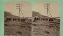
| Date: | 04 18 1888 |
|---|---|
| Description: | Stereograph of fireplace ruins on the site of an old French fort, possibly built by Nicholas Perrot. There is an electric pole behind the fireplace and a g... |
If you didn't find the material you searched for, our Library Reference Staff can help.
Call our reference desk at 608-264-6535 or email us at: