 Filter: Categories of Wisconsin Historical Images
Filter: Subject of City halls
Filter: Subject of church buildings
Filter: Categories of Wisconsin Historical Images
Filter: Subject of City halls
Filter: Subject of church buildings

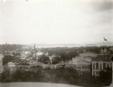
| Date: | 1880 |
|---|---|
| Description: | Bird's-eye map over the Mississippi River of Fountain City. Paddle steamers and steamboats are on the river, and bluffs are in the background. |
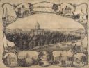
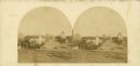
| Date: | 1864 |
|---|---|
| Description: | Bird's-eye view of Madison, with 12 vignettes and in the center is "The Capitol of Wisconsin View from the Capitol House". The buildings on the top are, fr... |
| Date: | 1873 |
|---|---|
| Description: | View, ca. 1873-1879, of Madison looking down Wisconsin Avenue toward the third Wisconsin Capitol, a view that suggests something of the ongoing importance ... |
| Date: | |
|---|---|
| Description: | A view looking south down Wisconsin Avenue toward the Capitol Square where portions of the second and third Wisconsin State Capitols are visible. This pers... |

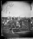
| Date: | 1915 |
|---|---|
| Description: | Wisconsin Avenue looking toward the northwest from the top of the Capitol. The elevated perspective provides an unusual view of the old City Hall (left) an... |

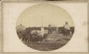
| Date: | 1868 |
|---|---|
| Description: | Elevated view up Wisconsin Avenue showing City Hall on the corner at Mifflin Street on the left, with the Post Office to the right. Further down is the Pre... |
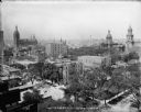
| Date: | 09 14 1913 |
|---|---|
| Description: | Looking northwest from the roof of Northwestern Mutual home office at E. Wisconsin Avenue and N. Van Buren Street toward City Hall, Milwaukee courthouse an... |
| Date: | 1896 |
|---|---|
| Description: | View from the Wisconsin State Capitol dome looking west towards Bascom Hill. Mifflin street with City Hall and the Fuller Opera House are in the foreground... |

| Date: | 09 1954 |
|---|---|
| Description: | Elevated view of Wisconsin Avenue from the Wisconsin State Capitol balcony. At the lower left, the demolition of old City Hall is in progress, which began ... |

| Date: | 1954 |
|---|---|
| Description: | Looking northwest down Wisconsin Avenue from the Wisconsin State Capitol dome. Mifflin Street is visible in the foreground, while in the center of the phot... |
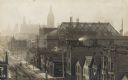
| Date: | 1910 |
|---|---|
| Description: | Elevated view looking east between Second and Third streets. City Hall is visible in the left center background. Signs and billboards dot several buildin... |
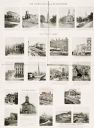
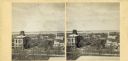
| Date: | 10 13 1895 |
|---|---|
| Description: | Twenty-one photographs of churches, city halls, courthouses, and other buildings and their locations throughout Milwaukee. |
| Date: | |
|---|---|
| Description: | A view looking south down Wisconsin Avenue toward the Capitol Square where portions of the second and third Wisconsin State Capitols are visible. This pers... |
| Date: | |
|---|---|
| Description: | Elevated view up Wisconsin Avenue showing City Hall with the Post Office to the right. Also visible is the Presbyterian Church. |

| Date: | |
|---|---|
| Description: | Composite of three historical landmarks in Northfield, New Hampshire: the Town House, the Old Mill, and the Congregational Church. The Church has "Congrega... |
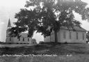
| Date: | 1931 |
|---|---|
| Description: | A tree near the city hall. The church, with a bell tower, is nearby in the background. |
| Date: | |
|---|---|
| Description: | View of Branford Town Hall and First Congregational Church, two Greek Revival buildings are located near a monument. The town hall was built in 1857 and f... |

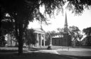
| Date: | 1957 |
|---|---|
| Description: | Large Letter style postcard for Green Bay depicting various scenes in the letters that spell the name of the city. Caption reads: "Greetings from Green Bay... |

| Date: | 1909 |
|---|---|
| Description: | A map of Langlade County, Wisconsin that shows townships and ranges, towns, cities and villages, wagon roads, churches, schools, sawmills, town halls, chee... |

| Date: | 1926 |
|---|---|
| Description: | A map of Lincoln County, Wisconsin that shows the township and range grid, towns, cities and villages, lakes and streams, residences, churches, school hous... |
If you didn't find the material you searched for, our Library Reference Staff can help.
Call our reference desk at 608-264-6535 or email us at: