 Filter: Categories of Wisconsin Historical Images
Filter: Subject of Cities and towns
Filter: Subject of courts
Filter: Categories of Wisconsin Historical Images
Filter: Subject of Cities and towns
Filter: Subject of courts
| Date: | 1890 |
|---|---|
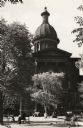
| Description: | Detail of the photograph of the Third Capitol showing the North Wing addition completed in 1883. Designed by D.R. Jones, the North and South additions were... |
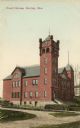
| Date: | 1905 |
|---|---|
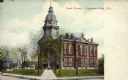
| Description: | View across road toward the court house. Caption reads: "Court House, Hurley, Wis." |
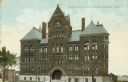
| Date: | 1900 |
|---|---|
| Description: | Exterior of the Dane County Courthouse, 207 W. Main Street. Caption reads: "Dane County Courthouse, Madison, Wis." |
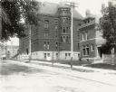
| Date: | 1920 |
|---|---|
| Description: | The Dane County Courthouse, 207 West Main Street, and Dane County Jail, 219 West Main Street. |
| Date: | 1922 |
|---|---|
| Description: | The Dane County Courthouse on West Main Street, built in 1885. |
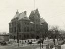
| Date: | 1889 |
|---|---|
| Description: | Dane County Courthouse, begun in the fall of 1883 and finished in the spring of 1886. The cost, including equipment, was a little over $180,000. |

| Date: | 1905 |
|---|---|
| Description: | Color image of courthouse with a large tree and park on the left. View taken at an angle to the building from across the street. Horse-drawn carriages are ... |
| Date: | 1940 |
|---|---|
| Description: | Side view of courthouse. Several cars are parked on the road lining the courthouse, and a woman is stepping onto the sidewalk near a fire hydrant. |
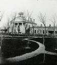
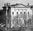
| Date: | 1865 |
|---|---|
| Description: | Courthouse built in 1836, then torn down in 1871 to make way for a new structure. Tall central building with two wings coming off the sides. Path in fron... |
| Date: | 1940 |
|---|---|
| Description: | Front view of the courthouse, with several trees. People are sitting at various benches and tables in the space in front of the courthouse, and pigeons ar... |

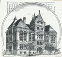
| Date: | 1870 |
|---|---|
| Description: | Slightly elevated view at an angle towards the left and front of the courthouse. A large statue is on top of the main dome. The area around the courthouse ... |

| Date: | |
|---|---|
| Description: | Elevated view across the tree lined city park towards the high school, courthouse, and bandstand. |
| Date: | 1900 |
|---|---|
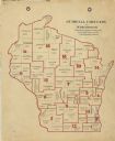
| Description: | A map of Wisconsin showing the seventeen judicial circuits of the state. The map also shows the counties of Wisconsin and the total population of each of t... |
| Date: | 1922 |
|---|---|
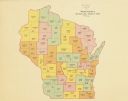
| Description: | A map of Wisconsin showing the state’s judicial districts, it also provides the population total for each county. |

| Date: | 1845 |
|---|---|
| Description: | Wisconsin was considered part of Michigan Territory until 1836, a year before Michigan entered statehood. Drawn three years before Wisconsin entered stateh... |

| Date: | 1915 |
|---|---|
| Description: | Color postcard of Chippewa County Court House at Chippewa Falls. Caption reads: "Chippewa County Court House, Chippewa Falls, Wis." |
| Date: | 1909 |
|---|---|
| Description: | Color postcard showing corner view of Chippewa County Court House. On the left is a bandstand on the court house front lawn and two houses on the next bloc... |
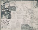
| Date: | 1926 |
|---|---|
| Description: | These maps are composites of selected exhibits and evidence submitted to the Supreme Court by the states of Wisconsin and Michigan between 1923 and 1926. T... |

| Date: | 1904 |
|---|---|
| Description: | Map showing lots, additions, and wards within the city limits, as well as some landownership. The streets are labeled, as is Lake Winnebago, rivers, railro... |

| Date: | 1770 |
|---|---|
| Description: | The south west sheet of a four sheet map of Virginia, showing the counties, mountains, rivers, court houses, a few cities, and mills. A few Plantations ar... |
If you didn't find the material you searched for, our Library Reference Staff can help.
Call our reference desk at 608-264-6535 or email us at: