 Filter: Categories of Wisconsin Historical Images
Filter: Subject of Cities and towns
Filter: Community of Prairie du Chien
Filter: Categories of Wisconsin Historical Images
Filter: Subject of Cities and towns
Filter: Community of Prairie du Chien

| Date: | 1857 |
|---|---|
| Description: | This map shows lots and streets and includes pencil manuscript notations on the front and certification statements on the reverse. The top left margin read... |

| Date: | 1828 |
|---|---|
| Description: | This plat map is pen-and-ink and shows landowners, the Mississippi River, the Marais de St. Friole, Fort Crawford, the town commons, and the Village of St.... |

| Date: | 09 01 1856 |
|---|---|
| Description: | This map is pen-and-ink and shows farm lots, other lots of land sectioned by acres, bluffs, and a coulee. Also included are notations in pencil and blue in... |

| Date: | 1858 |
|---|---|
| Description: | This map shows streets, lots, and landownership. Also included are notations in pencil and blue colored pencil. Some lots are colored in blue, green, or br... |

| Date: | 1855 |
|---|---|
| Description: | This map shows streets and lots. The right side of the map includes notes on widths of streets and certifications. The top right reads: "Parish's Addition ... |
| Date: | |
|---|---|
| Description: | This map shows farm lots and private land claims on Prairie du Chien. The bottom left margin reads: "Part of sec. 1, T6 N, R 7W and sec. 36, T 7N, R 7W. S... |

| Date: | 1865 |
|---|---|
| Description: | This is a collection of two plat maps. The first map shows lots, streets, and farm lot 25. Written in ink, the top of the map reads: Plat of Prairie du Chi... |

| Date: | 1856 |
|---|---|
| Description: | This map shows lot and block numbers, streets, depot building, and the Milwaukee & Mississippi Rail Road. |

| Date: | 05 21 1855 |
|---|---|
| Description: | This plat map shows lots, the Kickapoo River, and the Wisconsin River. |

| Date: | 07 28 1934 |
|---|---|
| Description: | This map shows buildings and dimensions of Fort Crawford and hospital overlaid on a plat of existing lots, streets, and closed streets. |
| Date: | 1856 |
|---|---|
| Description: | This map is ink and watercolor on paper and includes certifications inscribed by Saml. T. [M?]ight, a civil engineer, Edward H. Brodhead, James H. Lockwood... |

| Date: | 1828 |
|---|---|
| Description: | This map is pen-and-ink and served as the model for the lithograph produced in 1828 by C.B. Graham. Landowners are labeled as is the Mississippi River. |

| Date: | |
|---|---|
| Description: | This map is pen-and-ink on tracing paper with a mounted legend and shows the Kickapoo River, Indian mounds, the 1st Fort Crawford, an Indian Agency, the si... |
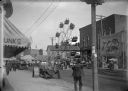
| Date: | 1912 |
|---|---|
| Description: | View from sidewalk of a street carnival with tents, circus banners and a Ferris Wheel set up in the middle of the street. Signboards advertise ice cream an... |
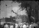
| Date: | 1912 |
|---|---|
| Description: | View from crowd of a pair of trapeze acrobats performing at a street fair. |

| Date: | 1900 |
|---|---|
| Description: | This map shows a line, marked with latitude and longitude coordinates that runs through Prairie du Chien. Only a few features beyond this line are displaye... |

| Date: | 1900 |
|---|---|
| Description: | This photocopy map shows proposed buildings and building use at Fort Crawford. |

| Date: | 1900 |
|---|---|
| Description: | This photocopy map shows marshes, woods, buildings, and selected features including islands, mounds, old Fort Crawford, and "new site for a fort in questio... |
| Date: | 1930 |
|---|---|
| Description: | This photocopy map includes cross section of buildings. |

| Date: | 1942 |
|---|---|
| Description: | This photocopy plat map represents the relative position and size of the sloughs and islands in the Mississippi River, opposite Prairie du Chien. |
If you didn't find the material you searched for, our Library Reference Staff can help.
Call our reference desk at 608-264-6535 or email us at: