 Filter: Categories of Wisconsin Historical Images
Filter: Subject of Cemeteries
Filter: Subject of streets
Filter: Subject of architecture
Filter: Categories of Wisconsin Historical Images
Filter: Subject of Cemeteries
Filter: Subject of streets
Filter: Subject of architecture

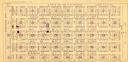
| Date: | 1881 |
|---|---|
| Description: | Bird's-eye map of Milton Junction. |
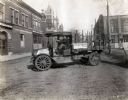
| Date: | 1919 |
|---|---|
| Description: | International model "F" "31" truck operated by Striplins Transfer of Litchfield. A male driver is in the truck which is parked on a city street between a ... |

| Date: | |
|---|---|
| Description: | A stone archway over the entrance of Cypress Hill Cemetery. |
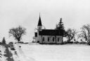
| Date: | 02 16 1978 |
|---|---|
| Description: | "Zion Lutheran Church, Town of Theresa. At this moment, funeral services of Herb Sellnow are taking place." |

| Date: | 1947 |
|---|---|
| Description: | Shows lot and block numbers, 28 points of interest in the upper left that correspond to numbers on the map, and landownership with acreages. "Erickson Brot... |

| Date: | 1911 |
|---|---|
| Description: | View down center of Main Street. On the left is the Hotel Lewis, with a columned porch and awnings above the second-story windows. Further down the street ... |
| Date: | 1943 |
|---|---|
| Description: | Map shows the town of St. Catherine, Wisconsin, between Lake Street and Doty Street as it appeared on January 3, 1852. Map is situated facing north with La... |
| Date: | |
|---|---|
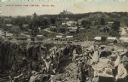
| Description: | Partially colorized view looking down at a quarry. On the other side of the quarry is the town of Berlin, with dwellings and commercial buildings. Caption ... |
| Date: | 1870 |
|---|---|
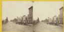
| Description: | Stereograph view of Oconomowoc. |

| Date: | 1888 |
|---|---|
| Description: | This map has relief shown by hachures and features inset maps of a plat of E.D. Clinton and Blackwell’s add’n to the City of La Crosse. Wards (1-10) shaded... |

| Date: | 1857 |
|---|---|
| Description: | This map shows section corners, quarter section corners, foundry, steam saw mill, steam grist mill, planning mill, court house, baptist church, congregatio... |

| Date: | 1927 |
|---|---|
| Description: | This map includes an index and highways marked in red. Attractions on the map include: Four Mile House, Cold Springs, Grand Crossing Station, Coleman Sloug... |

| Date: | 1929 |
|---|---|
| Description: | This is a blue line print map that shows local streets, railroads, local businesses, schools, parks, cemeteries, the airport, the state capitol, the Univer... |

| Date: | 1976 |
|---|---|
| Description: | This map includes an index of streets, government and historic buildings, hospitals, schools, places of recreation, churches, cemeteries, and other miscell... |

| Date: | 1883 |
|---|---|
| Description: | This map shows ward boundaries, names of additions, streets, bridges, mills, schools, religious buildings, businesses, hotels, railroads, factories, brewer... |

| Date: | 1857 |
|---|---|
| Description: | This map shows land ownership by name, local streets, wards, buildings, parks, a cemetery, and part of Lake Michigan. Depths are shown by soundings and nor... |

| Date: | 1934 |
|---|---|
| Description: | This map is attached to a cover. Streets, points of interest, the Milwaukee River, and Lake Michigan are labeled. The bottom margin of the map includes a s... |

| Date: | 1890 |
|---|---|
| Description: | This map shows lot and block numbers and dimensions, landownership, city wards, buildings, streets, railroads, parks, cemeteries, churches, schools, and in... |

| Date: | 1891 |
|---|---|
| Description: | This hand-colored map shows platted additions and subdivisions, ward boundaries, schools, churches, railroads, cemeteries, parks, businesses, factories, an... |

| Date: | 1893 |
|---|---|
| Description: | This map shows city wards, block numbers, parks, cemeteries, roads, railroads, selected buildings, and Lake Michigan. Also included are indexes to streets,... |
If you didn't find the material you searched for, our Library Reference Staff can help.
Call our reference desk at 608-264-6535 or email us at: