 Filter: Categories of Wisconsin Historical Images
Filter: Subject of Cemeteries
Filter: Subject of industries
Filter: Categories of Wisconsin Historical Images
Filter: Subject of Cemeteries
Filter: Subject of industries
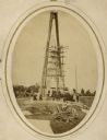
| Date: | 1869 |
|---|---|
| Description: | Governor Lucius Fairchild of Wisconsin and an unidentified group visiting the still uncompleted national monument at Gettysburg, Pennsylvania in 1869. Fair... |
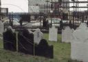
| Date: | 1969 |
|---|---|
| Description: | Cemetery with a view across the street of the World Trade Center construction site. |
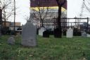
| Date: | 1969 |
|---|---|
| Description: | View of the construction of the World Trade Center from the churchyard at St. Paul's Chapel. |
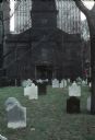
| Date: | 1969 |
|---|---|
| Description: | View of cemetery of St. Paul's Chapel with gravestones. In the background is the construction of the World Trade Center. |
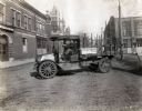
| Date: | 1919 |
|---|---|
| Description: | International model "F" "31" truck operated by Striplins Transfer of Litchfield. A male driver is in the truck which is parked on a city street between a ... |
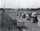
| Date: | 07 25 1925 |
|---|---|
| Description: | A line of International trucks are parked in a line along a dirt road lined with fences and power lines. Each truck has a load of dirt, and metal forms are... |
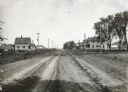
| Date: | 05 30 1916 |
|---|---|
| Description: | View down center of rural dirt road with houses along both sides in Black Hawk County. A man and horse are in a field on the left, near a sign that says: "... |

| Date: | 02 05 1978 |
|---|---|
| Description: | "Union Cemetery — The graves are awash in snow in the aftermath of the late January snowstorm." |

| Date: | 1972 |
|---|---|
| Description: | This map on 5 sheets features a title page sheet with business directory and shows section numbers, roads, railroads, saw mills, churches, blacksmith shops... |

| Date: | 1870 |
|---|---|
| Description: | A map of Iowa County, Wisconsin mounted on cloth that shows the villages of Avoca, Mifflin, Linden, Arena, Helena Station, Highland, Dodgeville, as well as... |

| Date: | 1862 |
|---|---|
| Description: | This map shows townships and sections, landownership and acreages, roads, railroads, cemeteries, churches, schools, mills, and stone quarries. "Engraved, p... |

| Date: | 1887 |
|---|---|
| Description: | This late 19th century map shows the lake region around Oconomowoc in Waukesha County and eastern Jefferson County, Wisconsin. Cities and villages, roads, ... |

| Date: | 1914 |
|---|---|
| Description: | Map shows school houses, creameries, post offices, saw mills, grist mills, churches, cemeteries, town halls, stores, roads, state roads, and railroads. "Co... |

| Date: | 1976 |
|---|---|
| Description: | Panel title. Shows railroads, roads, highways, boundaries, dams, public hunting and fishing grounds, cemeteries, forest ranger stations, plant life, and s... |
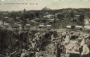
| Date: | |
|---|---|
| Description: | Partially colorized view looking down at a quarry. On the other side of the quarry is the town of Berlin, with dwellings and commercial buildings. Caption ... |

| Date: | 1888 |
|---|---|
| Description: | This map has relief shown by hachures and features inset maps of a plat of E.D. Clinton and Blackwell’s add’n to the City of La Crosse. Wards (1-10) shaded... |

| Date: | 1857 |
|---|---|
| Description: | This map shows section corners, quarter section corners, foundry, steam saw mill, steam grist mill, planning mill, court house, baptist church, congregatio... |

| Date: | 1891 |
|---|---|
| Description: | This hand-colored map shows platted additions and subdivisions, ward boundaries, schools, churches, railroads, cemeteries, parks, businesses, factories, an... |

| Date: | 1858 |
|---|---|
| Description: | This map shows city wards, streets, block and lot numbers, cemeteries, buildings, landownership, forests, railroads, a race course, quarries, and orchards.... |

| Date: | 06 12 1929 |
|---|---|
| Description: | This manuscript blueprint shows buildings with the names of their owners, tabernacle, location "where Strang found plates" and "house where Strang died," a... |
If you didn't find the material you searched for, our Library Reference Staff can help.
Call our reference desk at 608-264-6535 or email us at: