 Filter: Categories of Wisconsin Historical Images
Filter: Subject of Canoes and canoeing
Filter: Categories of Wisconsin Historical Images
Filter: Subject of Canoes and canoeing

| Date: | 2005 |
|---|---|
| Description: | This map shows dams and falls, areas of portage, canoe and kayak access, boat launches, parking, restrooms, picnic areas, dining, rapid water, parks, and b... |

| Date: | |
|---|---|
| Description: | View towards a shoreline where a man is facing away while urinating on a tree along a riverbank. Buildings are on the opposite side of the river and canoes... |

| Date: | 1910 |
|---|---|
| Description: | View across water towards an Ojibwe couple paddling a birch bark canoe with their five children seated in the center. The family is dressed in western styl... |
| Date: | |
|---|---|
| Description: | Drawing attached to wall depicting a man canoeing and attempting to pull an innertube or raft with a woman on board. The woman is wearing a hat and appears... |

| Date: | |
|---|---|
| Description: | A man relaxing in a canoe on a river or lake. Behind him is a rock formation covered with trees. |

| Date: | 1877 |
|---|---|
| Description: | Engraving of the Peck Cabin, after the painting by Mrs. E.E. Bailey. Caption at bottom reads: "First House in Madison. 1837." |

| Date: | 1930 |
|---|---|
| Description: | A lantern slide reproduction of a printed image of a Chippewa camp. Two dogs, center, are facing the camera. Two birch bark covered tipis are on the left; ... |
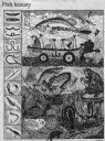
| Date: | 05 07 1988 |
|---|---|
| Description: | Imaginative pen-and-ink drawing that appeared in the Capitol Times on May 7, 1988 with Sid's caption: "Fish history begins with hooks made of wood, ... |

| Date: | 1783 |
|---|---|
| Description: | This map is hand-colored and shows the boundaries of British, Spanish, and the newly recognized American claims, as well as the fishing rights granted to F... |

| Date: | 1921 |
|---|---|
| Description: | This map shows in red the NorthWestern Railway Line routes running from Chicago, Illinois to northern Wisconsin and Michigan. The map includes cities and t... |

| Date: | 1922 |
|---|---|
| Description: | This map shows in red the NorthWestern Railway Line routes running from Chicago, Illinois to northern Wisconsin. The map includes cities and towns, lakes, ... |

| Date: | 1909 |
|---|---|
| Description: | View through trees towards Willow Point at Delavan Lake. Caption reads: "Willow Point, Delavan Lake, Wis." |

| Date: | 1914 |
|---|---|
| Description: | Hand-colored view towards shoreline of the Assembly Grounds along Delavan Lake. Row boats and canoes are pulled up on the shoreline. Caption reads: "Assemb... |

| Date: | 1783 |
|---|---|
| Description: | Map of eastern Canada and part of America, with an inset map of the Great Lakes region in the lower left corner. It shows boundaries, cities, settlements, ... |

| Date: | 1776 |
|---|---|
| Description: | Map showing New England, Nova Scotia, and Newfoundland, based on the seminal work of D' Anville, as well as the works of Belllin and de Vaugondy. It shows ... |

| Date: | 1718 |
|---|---|
| Description: | Map of the Southern portion of North America from New Mexico to Florida and south from Lake Erie. It shows borders, cities, settlements, Native American la... |

| Date: | 1905 |
|---|---|
| Description: | Campers on Picnic Point. Tents are set up along the shore, under the trees. A few campers are in front of their tents. A canoe is barely visible on the rig... |

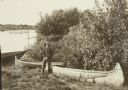
| Date: | |
|---|---|
| Description: | A Native American man from the Mille Lacs and Rainy Lake area in Minnesota. He is probably Chippewa (Ojibwa). Behind him are paddles leaning on a tree and ... |
| Date: | 1907 |
|---|---|
| Description: | View down shoreline towards the travelers pausing in their canoe journey to have lunch on the riverbank below Gordon Dam. |
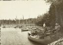
| Date: | 1907 |
|---|---|
| Description: | One of the boys (probably Carl) posing next to two canoes at an Indian village below Pansy. |
If you didn't find the material you searched for, our Library Reference Staff can help.
Call our reference desk at 608-264-6535 or email us at: