Filter: Categories of Wisconsin Historical Images
Filter: Subject of Canals
Filter: Year of 1800-1899
Filter: Year of 1870-1879
Filter: Categories of Wisconsin Historical Images
Filter: Subject of Canals
Filter: Year of 1800-1899
Filter: Year of 1870-1879

| Date: | 1872 |
|---|---|
| Description: | Birds-eye drawing of Eau Claire depicts street names and street locations, houses, trees, bridges, piers, canals, railroads, and the Chippewa and Eau Clair... |

| Date: | 1875 |
|---|---|
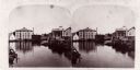
| Description: | The harbor piers and the entrance to the Sturgeon Bay ship canal. Men are standing on the shoreline. |

| Date: | 1870 |
|---|---|
| Description: | The corner of unpaved Main Street and Tayco Street looking south towards Doty Island. The slanting timbers controlled the primitive draw bridge across the ... |

| Date: | 1878 |
|---|---|
| Description: | This map shows block numbers, wards, roads, railroads, parks, and selected buildings and includes a "Milwaukee city street guide" as well as a guide to pub... |

| Date: | 1873 |
|---|---|
| Description: | Engraved image of a lock and dam at Sault St. Marie. Two men are operating the sluice as ships are waiting on the opposite side of the lock. Another man is... |

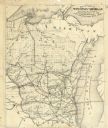
| Date: | 1872 |
|---|---|
| Description: | This 1872 map shows the proposed route of a canal between Sturgeon Bay, on the Green Bay side of the Door Peninsula, and Lake Michigan. Depths in both Stur... |

| Date: | 1874 |
|---|---|
| Description: | Bird's-eye view map of Appleton, Wisconsin. Map reads: "NOTE.-Since the above cut was engraved, the Fox River Pulp & Paper Co.'s Mammoth Mills have been er... |

| Date: | 1876 |
|---|---|
| Description: | This map is of the towns of Neenah and Menasha and shows existing and proposed canals. Water depths shown by soundings. Little Butte des Morts Lake, Doty I... |

| Date: | 1871 |
|---|---|
| Description: | This map shows railroads, canals, towns and some lighthouses. Areas of the company lands proper, tin, iron, gold & silver, silver islet, and lead are color... |
| Date: | 1878 |
|---|---|
| Description: | This map shows the advantages of the Sturgeon Bay and Lake Michigan Ship Canal, railroads, steamship lines across Lake Michigan, and Wisconsin township gri... |

| Date: | 1874 |
|---|---|
| Description: | Birds-eye view of Appleton Wisconsin. In the foreground are people fishing, strolling, and looking over the canal towards the Fox River. Streets and buildi... |
If you didn't find the material you searched for, our Library Reference Staff can help.
Call our reference desk at 608-264-6535 or email us at: