 Filter: Categories of Wisconsin Historical Images
Filter: Subject of Canals
Filter: Subject of water
Filter: Categories of Wisconsin Historical Images
Filter: Subject of Canals
Filter: Subject of water
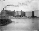
| Date: | 1900 |
|---|---|
| Description: | View of factory buildings and smokestacks from across a river or industrial canal. The factory is probably the McCormick Reaper Works as seen from across t... |

| Date: | 1853 |
|---|---|
| Description: | Wisconsin counties by color and shows railroads, common roads, canals, the state capital, county towns, townships, villages, and post offices, |

| Date: | 1854 |
|---|---|
| Description: | Map of the whole state Wisconsin includes an inset of the vicinity of Milwaukee, which shows the boundaries for Lisbon, Menomonee, Pewaukee, Brookfield, Wa... |

| Date: | 1857 |
|---|---|
| Description: | This detailed map was drawn nearly a decade after Wisconsin entered statehood. It depicts the entire state, northern Illinois and part of the upper peninsu... |
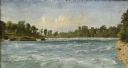
| Date: | 1856 |
|---|---|
| Description: | "....The third view was twelve miles farther up the river [from De Pere], at Rapid Croche, on the border of the present Brown and Outagamie counties. It is... |

| Date: | 1856 |
|---|---|
| Description: | ". . . The upper Grand Chute was the last of the 'improvements' paintings signed by Brookes and Stevenson. Yet there were two more vital links in the Fox R... |

| Date: | 1847 |
|---|---|
| Description: | A hand-colored map that shows the area south and east of the Wisconsin and Fox Rivers, as well as a few landmarks just north of that area. The township gri... |

| Date: | 1839 |
|---|---|
| Description: | This map shows the township and section grid, lakes, rivers, swamps, prairies, roads, and proposed canals in the area of Wisconsin south of Lake Winnebago ... |

| Date: | 1839 |
|---|---|
| Description: | Wisconsin was considered part of Michigan Territory until 1836, a year before Michigan entered statehood. Drawn in 1839, this map shows the state of Michig... |

| Date: | 1840 |
|---|---|
| Description: | This hand-colored map shows the township and section grid in southeastern Wisconsin, covering the area west to Sugar River and Four Lakes region and north ... |

| Date: | 1844 |
|---|---|
| Description: | Wisconsin was considered part of Michigan Territory until 1836, a year before Michigan entered statehood. Drawn four years before Wisconsin entered stateho... |

| Date: | 1845 |
|---|---|
| Description: | Wisconsin was considered part of Michigan Territory until 1836, a year before Michigan entered statehood. Drawn three years before Wisconsin entered stateh... |

| Date: | 1854 |
|---|---|
| Description: | Brightly-colored map exhaustively marks the townships, County Towns and villages of Wisconsin. It also shows rivers, canals, railroads, and plank roads. Ea... |

| Date: | 1939 |
|---|---|
| Description: | This nine-part map from the U.S. Bureau of Public Roads identifies federal and state highways in Wisconsin by pavement type. County, forest, park, and publ... |

| Date: | 1944 |
|---|---|
| Description: | This nine-part map from the U.S. Bureau of Public Roads identifies federal and state highways in Wisconsin by pavement type. County, forest, park, and publ... |

| Date: | 1866 |
|---|---|
| Description: | This map shows the railroads both completed and under construction in southern Wisconsin, Iowa, Illinois, and Missouri. Railroad terminals, junctions, and ... |

| Date: | 1906 |
|---|---|
| Description: | A hand-colored commercial map of Wisconsin and portions of eastern Minnesota, Iowa, northern Illinois, and the Michigan’s Upper Peninsula. The map shows ra... |
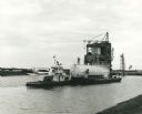
| Date: | 1967 |
|---|---|
| Description: | NASA towboat, the "Clermont", pulling a liquid oxygen tank in the canal system of the Mississippi Test Support Department. Original caption reads (in part)... |

| Date: | 1853 |
|---|---|
| Description: | Engraved image of a boat being towed through a canal at Little Falls by a team of horses. A small town is in the background. |

| Date: | 1873 |
|---|---|
| Description: | Engraved image of a lock and dam at Sault St. Marie. Two men are operating the sluice as ships are waiting on the opposite side of the lock. Another man is... |
If you didn't find the material you searched for, our Library Reference Staff can help.
Call our reference desk at 608-264-6535 or email us at: